1940s Maps of Hatillo
Explore 4 historic maps of Hatillo from the 1940s. These maps offer a rare glimpse into what life looked like during the 1940s — showing old roads, neighborhoods, homes, and landmarks that have changed or disappeared over time.
Whether you're researching your family's past, planning a metal detecting trip, or studying how Hatillo's landscape evolved across the 1940s, these high-resolution maps are a powerful tool for exploring the history of this region.
- Focus on a specific era: All maps on this page are from the 1940s, giving you a focused view of this time period.
- See what’s changed: Compare century-old streets, trails, and buildings to today's modern landscape using overlays and satellite layers.
- Research with precision: Use these maps for genealogy, historical research, land use analysis, or educational projects.
- View, download, or print: Maps are fully viewable online in high resolution, and can be downloaded or printed for your own records.
Start exploring Hatillo's history through authentic maps from the 1940s. This is your window into the past.
Hatillo maps
(4)- 1942 Map of Camuy
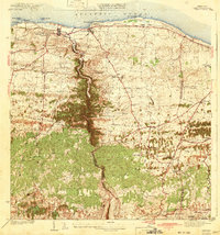 1942 Camuy1942 Print · USGSThe northern coast of Puerto Rico is seen here during the pre-war era, where the coastal railroad linked bustling towns to the agricultural interior. Genealogists can trace family footprints through rural neighborhoods like Pueblo Nuevo and landmarks such as Iglesia Santa Teresita or Estacion Luchi.6 unique versions available
 - 1946 Map of Bayaney
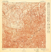
 1946 Bayaney1946 Print · USGSThe interior highlands of Puerto Rico are detailed here in the late 1940s, showcasing a landscape of isolated ridges and river-valley settlements. Researchers can trace local history through named rural schools like Escuela La America and settlements such as Angeles and Bayaney.4 unique versions available
 - 1947 Map of Bayaney NE
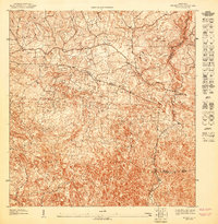
 1947 Bayaney NE1947 Print · USGSThe northern interior of Puerto Rico is captured here in the mid-1940s, showing the dense settlement patterns around Bayaney. Local historians can trace early property boundaries and rural roads near the Tanama and the municipal junctions of Hatillo and Arecibo.
 - 1947 Map of Bayaney NO
 1947 Bayaney NO1947 Print · USGSThe interior of northwestern Puerto Rico comes into focus in the late 1940s as rural communities began to expand. Genealogists and researchers can trace the specific boundaries of the Municipio de Lares and locate local landmarks like the Escuela Theodore Roosevelt.
End of results
Showing maps 1-4 of 4
Frequently asked questions
- What are the different types of historical maps available for Hatillo?
- What is the oldest map of Hatillo?
- Where can I purchase historical maps of Hatillo for my home or office?
- Where can I download high-res historical maps of Hatillo?
- Are there historical topographic maps available for Hatillo?
- Is there historical aerial imagery available for Hatillo?
- Where are historical maps of Hatillo sourced from?