1940s Maps of Hormigueros
Explore 6 historic maps of Hormigueros from the 1940s. These maps offer a rare glimpse into what life looked like during the 1940s — showing old roads, neighborhoods, homes, and landmarks that have changed or disappeared over time.
Whether you're researching your family's past, planning a metal detecting trip, or studying how Hormigueros's landscape evolved across the 1940s, these high-resolution maps are a powerful tool for exploring the history of this region.
- Focus on a specific era: All maps on this page are from the 1940s, giving you a focused view of this time period.
- See what’s changed: Compare century-old streets, trails, and buildings to today's modern landscape using overlays and satellite layers.
- Research with precision: Use these maps for genealogy, historical research, land use analysis, or educational projects.
- View, download, or print: Maps are fully viewable online in high resolution, and can be downloaded or printed for your own records.
Start exploring Hormigueros's history through authentic maps from the 1940s. This is your window into the past.
Hormigueros maps
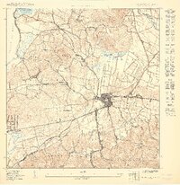
(6)- 1941 Map of San German
 1941 San German1941 Print · USGSThe hills and valleys surrounding San Germán come alive in this early 1940s survey, showing the peak of the railroad era in southwest Puerto Rico. Researchers can trace the American Railroad of Porto Rico through a landscape of historic estates like Hacienda Beatriz Soledad and Hacienda Resolucion.5 unique versions available
 - 1941 Map of Puerto Real
 1941 Puerto Real1941 Print · USGSCoastal life in southwestern Puerto Rico centered on the harbor at Puerto Real and the rail line at Cabo Rojo during the late thirties and early forties. Local historians can trace the American Railroad corridor and locate old landmarks like Cementerio Delicias and the salt works at Las Salinas.4 unique versions available
 - 1941 Map of Rosario, 1952 Print
 1941 Rosario1952 Print · USGSWestern Puerto Rico's mountain interior comes alive in this mid-century survey of the Rosario region. Researchers can trace ancestral lands through numerous named estates like Hacienda Juanita and Hacienda Esperanza, or locate early community centers such as Limon and Iglesia de San Jose.2 unique versions available
 - 1942 Map of Rosario
 1942 Rosario1942 Print · USGSWestern Puerto Rico is captured here in the era before widespread urbanization, showing the mountainous agricultural estates and early rail infrastructure. Genealogists can trace family holdings at Hacienda Esperanza or locate landmarks like the Hospital de Tuberculosis and American R. R.3 unique versions available
 - 1947 Map of Mayaguez
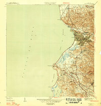 1947 Mayaguez1947 Print · USGSMayagüez and its thriving coastal economy are documented here in the late thirties, featuring the vital rail links of the American Railroad of Puerto Rico. Trace ancestral roots in Poblado Sabalos, Hormigueros, and along the sugar-rich Colonia Cornelia.4 unique versions available
 - 1949 Map of Puerto Real NE
 1949 Puerto Real NE1949 Print · USGSCabo Rojo and the western coast of Puerto Rico are captured here in the late forties, showing the region's transition from rural hills to seaside villages. Genealogists can locate family landmarks like Cementerio Delicias, the Iglesia Católica de Carmen, and the route of the American Railroad Company of Porto Rico.
End of results
Showing maps 1-6 of 6
Frequently asked questions
- What are the different types of historical maps available for Hormigueros?
- What is the oldest map of Hormigueros?
- Where can I purchase historical maps of Hormigueros for my home or office?
- Where can I download high-res historical maps of Hormigueros?
- Are there historical topographic maps available for Hormigueros?
- Is there historical aerial imagery available for Hormigueros?
- Where are historical maps of Hormigueros sourced from?