1960s Maps of Juana Díaz
Explore 5 historic maps of Juana Díaz from the 1960s. These maps offer a rare glimpse into what life looked like during the 1960s — showing old roads, neighborhoods, homes, and landmarks that have changed or disappeared over time.
Whether you're researching your family's past, planning a metal detecting trip, or studying how Juana Díaz's landscape evolved across the 1960s, these high-resolution maps are a powerful tool for exploring the history of this region.
- Focus on a specific era: All maps on this page are from the 1960s, giving you a focused view of this time period.
- See what’s changed: Compare century-old streets, trails, and buildings to today's modern landscape using overlays and satellite layers.
- Research with precision: Use these maps for genealogy, historical research, land use analysis, or educational projects.
- View, download, or print: Maps are fully viewable online in high resolution, and can be downloaded or printed for your own records.
Start exploring Juana Díaz's history through authentic maps from the 1960s. This is your window into the past.
Juana Díaz maps
(5)- 1960 Map of Jayuya, 1961 Print
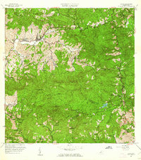 1960 Jayuya1961 Print · USGSThe Cordillera Central around Jayuya is documented here in the early sixties, showing a landscape of coffee haciendas and steep peaks. Researchers can trace historic estates like Hacienda Jurutungo and Hacienda Los Planes or locate the high elevations of Cerro de Punta.3 unique versions available
 - 1960 Map of Santa Isabel, 1962 Print
 1960 Santa Isabel1962 Print · USGSThe southern coast of Puerto Rico comes alive in this mid-century survey of the plains between the mountains and the Caribbean. Researchers can trace the layout of Central Cortada, find the locations of Hacienda Florida and Hacienda Alomar, or locate the Aeropuerto de Santa Isabel.2 unique versions available
 - 1960 Map of Rio Descalabrado, 1962 Print
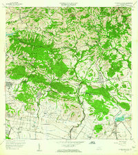 1960 Rio Descalabrado1962 Print · USGSCoastal plains and foothills near Santa Isabel and Juana Díaz are captured here during a period of agricultural and military significance. Researchers can trace historic estate boundaries at Hacienda Miranda and Hacienda Altura or locate local centers like Paso Seco.2 unique versions available
 - 1962 Map of Playa De Ponce, 1964 Print
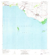
 1962 Playa De Ponce1964 Print · USGSThe Caribbean coast of southern Puerto Rico comes alive in this early 1960s survey, highlighting the bustling maritime hub at Playa de Ponce. Researchers can trace the waterfront around the Muelle de Ponce or explore offshore landmarks like Isla Caja de Muertos.
 - 1964 Map of Ponce, 1965 Print
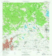 1964 Ponce1965 Print · USGSThe southern coast of Puerto Rico thrived in the mid-1960s as a hub of sugar production and urban growth. Genealogists and historians can trace family estates like Hacienda Maraguez and explore the industrial footprint of Central Mercedita and Fort Allen.
End of results
Showing maps 1-5 of 5
Frequently asked questions
- What are the different types of historical maps available for Juana Díaz?
- What is the oldest map of Juana Díaz?
- Where can I purchase historical maps of Juana Díaz for my home or office?
- Where can I download high-res historical maps of Juana Díaz?
- Are there historical topographic maps available for Juana Díaz?
- Is there historical aerial imagery available for Juana Díaz?
- Where are historical maps of Juana Díaz sourced from?