1970s Maps of Juana Díaz
Explore 4 historic maps of Juana Díaz from the 1970s. These maps offer a rare glimpse into what life looked like during the 1970s — showing old roads, neighborhoods, homes, and landmarks that have changed or disappeared over time.
Whether you're researching your family's past, planning a metal detecting trip, or studying how Juana Díaz's landscape evolved across the 1970s, these high-resolution maps are a powerful tool for exploring the history of this region.
- Focus on a specific era: All maps on this page are from the 1970s, giving you a focused view of this time period.
- See what’s changed: Compare century-old streets, trails, and buildings to today's modern landscape using overlays and satellite layers.
- Research with precision: Use these maps for genealogy, historical research, land use analysis, or educational projects.
- View, download, or print: Maps are fully viewable online in high resolution, and can be downloaded or printed for your own records.
Start exploring Juana Díaz's history through authentic maps from the 1970s. This is your window into the past.
Juana Díaz maps
(4)- 1970 Map of Playa De Ponce, 1972 Print
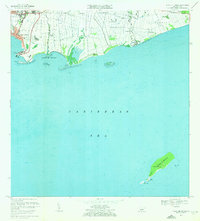 1970 Playa De Ponce1972 Print · USGSThe southern coast of Puerto Rico is captured here in the early seventies as industrial port activity and coastal barrios expanded. Genealogists and historians can trace family locations in Canas Urbano or offshore landmarks like Isla Caja de Muertos and Cayo Gata.3 unique versions available
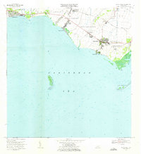
 - 1970 Map of Ponce, 1972 Print
 1970 Ponce1972 Print · USGSSouthern Puerto Rico in the early seventies shows a landscape balancing urban growth in Ponce with deep-rooted sugar traditions. Researchers can trace family estates and civic life through Central Mercedita, Hacienda Ana Maria, and Escuela Booker T Washington.4 unique versions available
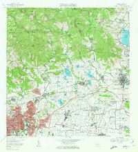
 - 1972 Map of Santa Isabel, 1973 Print
 1972 Santa Isabel1973 Print · USGSThe southern coast of Puerto Rico is captured here in the early seventies, showing a landscape defined by sugar history and maritime activity. Researchers can locate family estates like Hacienda Florida, the old Estación Santa Isabel, and coastal landmarks like Cayo Berbería.2 unique versions available
 - 1972 Map of Rio Descalabrado, 1974 Print
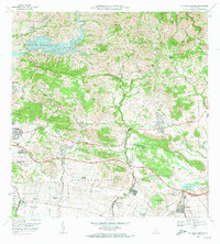 1972 Rio Descalabrado1974 Print · USGSSouthern Puerto Rico in the early seventies shows a transition from traditional sugarcane estates to modern infrastructure. Researchers can trace the boundaries of historic haciendas like Hacienda Amelia or locate the Fort Allen Naval Radio Station and Lago Coamo.4 unique versions available
End of results
Showing maps 1-4 of 4
Frequently asked questions
- What are the different types of historical maps available for Juana Díaz?
- What is the oldest map of Juana Díaz?
- Where can I purchase historical maps of Juana Díaz for my home or office?
- Where can I download high-res historical maps of Juana Díaz?
- Are there historical topographic maps available for Juana Díaz?
- Is there historical aerial imagery available for Juana Díaz?
- Where are historical maps of Juana Díaz sourced from?