1950s Maps of Marías, Moca
Explore 8 historic maps of Marías from the 1950s. These maps offer a rare glimpse into what life looked like during the 1950s — showing old roads, neighborhoods, homes, and landmarks that have changed or disappeared over time.
Whether you're researching your family's past, planning a metal detecting trip, or studying how Marías's landscape evolved across the 1950s, these high-resolution maps are a powerful tool for exploring the history of this region.
- Focus on a specific era: All maps on this page are from the 1950s, giving you a focused view of this time period.
- See what’s changed: Compare century-old streets, trails, and buildings to today's modern landscape using overlays and satellite layers.
- Research with precision: Use these maps for genealogy, historical research, land use analysis, or educational projects.
- View, download, or print: Maps are fully viewable online in high resolution, and can be downloaded or printed for your own records.
Start exploring Marías's history through authentic maps from the 1950s. This is your window into the past.
Marías, Moca maps
(8)- 1950 Map of Moca SO
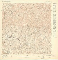 1950 Moca SO1950 Print · USGSMid-century Moca and its surrounding barrios are captured here during a period of infrastructure growth in northwest Puerto Rico. Genealogists and researchers can locate family homes and landmarks across Caimital Alto, the Escuela Segunda Unidad de Voladoras, and along the Río Culebrinas.
 - 1950 Map of Central La Plata NO
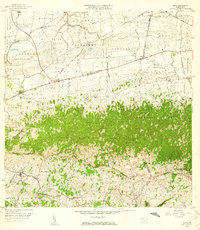
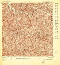 1950 Central La Plata NO1950 Print · USGSMoca's interior highlands are mapped here at mid-century, showing the dense rural settlement patterns of western Puerto Rico. Genealogists can trace family footprints across the barrios of Cerro Gordo and Voladoras along the winding Río Culebrinas.
 - 1950 Map of Rincon NE
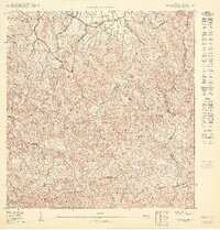 1950 Rincon NE1950 Print · USGSAguada and the high ridges of northwestern Puerto Rico are captured here at mid-century, before modern development transformed the mountain barrios. Local historians can trace the rural school and chapel network, including Capilla Malpaso and Escuela Segunda Unidad de Guanábano.
 - 1950 Map of Aguadilla SE
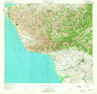
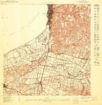 1950 Aguadilla SE1950 Print · USGSCoastal life in northwest Puerto Rico at mid-century is meticulously detailed where the mountains meet the Bahía de Aguadilla. Genealogists and historians can trace family locations through neighborhoods like Tamarindo, the path of the American Railroad, and rural schools like Escuela Segunda Unidad Espinal.
 - 1953 Map of Ciales
 1953 Ciales1953 Print · USGSCentral Puerto Rico’s mountainous interior comes alive in this mid-century survey of the rugged Ciales and Morovis highlands. Genealogists and historians can trace family roots through named barrios like Jaguas and Pesas, and locate rural landmarks such as Hacienda Maria and the Iglesia Ascensión.
 - 1955 Map of Central La Plata, 1958 Print
 1955 Central La Plata1958 Print · USGSThe mountainous interior of western Puerto Rico is captured here in the mid-fifties, dominated by the industrial site of Central La Plata. Genealogists and historians can trace numerous family-named landmarks and coffee-era estates, including Hacienda Morales, Hacienda Lambert, and Mata y Orsini.
 - 1955 Map of Rincon, 1958 Print
 1955 Rincon1958 Print · USGSWestern Puerto Rico in the mid-1950s shows a landscape of coastal sugar colonies and steep mountain barrios. Genealogists and historians can trace family locations through numerous named estates like Colonia Pagán, landmark schools, and the Faro at the island's edge.
 - 1956 Map of Moca, 1959 Print
 1956 Moca1959 Print · USGSMoca and the surrounding northwest highlands are shown here in the mid-fifties, during a period of transition between traditional agriculture and modern infrastructure. You can trace the Antigua Vía del Ferrocarril through the karst hills or locate family landmarks like Central Isabel No 2 and the Cementerio de Isabela.
End of results
Showing maps 1-8 of 8
Frequently asked questions
- What are the different types of historical maps available for Marías?
- What is the oldest map of Marías?
- Where can I purchase historical maps of Marías for my home or office?
- Where can I download high-res historical maps of Marías?
- Are there historical topographic maps available for Marías?
- Is there historical aerial imagery available for Marías?
- Where are historical maps of Marías sourced from?