1950 Map of Moca SO
USGS Topo · Published 1950About this map
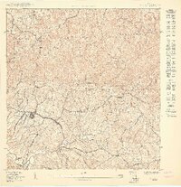
The town of Moca sits at the heart of this mid-century topographic survey, serving as a hub between the coastal plains of the northwest and the rising Cordillera Central. The map documents a rural landscape transitioning toward modern infrastructure, evidenced by the Planta de filtración and the centralized Escuela Segunda Unidad de Voladoras. The terrain is defined by the winding course of the Río Culebrinas and its tributaries, such as Quebrada Grande, which carve through the prominent limestone hills. High points like Monte El Ojo and Monte Marquilla overlook a network of barrios, including Aceitunas, Cuchillas, and Voladoras. This edition captures the precise boundary between the Municipio de Aguadilla and Moca, showing the density of residential structures along local roads like Monserrate and Brujas before late-century expansion.
Find a feature on this map
23 named features on this map. Tap any name to fly to it.
Don’t see what you’re looking for? This feature index may not catch every label — zoom into the map to look around manually.
Map Details
Editions of this 1950 Moca SO Map
This is the sole edition of this map. No revisions or reprints were ever made.
Other maps of this area

1937 · Aguadilla
USGS Topo · 1:20,000

1937 · Moca
USGS Topo · 1:20,000

1938 · Alto Sano
USGS Topo · 1:20,000

1941 · Moca
USGS Topo · 1:30,000

1941 · Rincon
USGS Topo · 1:30,000

1941 · Rincon
USGS Topo · 1:30,000

1942 · Moca
USGS Topo · 1:30,000

1942 · Central La Plata
USGS Topo · 1:30,000

1942 · Aguadilla
USGS Topo · 1:30,000

1946 · Ciales
USGS Topo · 1:30,000