
1941 Map of Moca
USGS Topo · Published 1941About this map
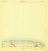
The Cordillera Jaicoa dominates the central landscape of this 1941 survey, where the rugged terrain of northwestern Puerto Rico is punctuated by peaks like Monte Encantado and Cerro El Sombrero. The northern plains are defined by the tracks of the American RR of Porto Rico, serving vital transit stops such as Estacion Montana and Estacion Arenales. This area reflects a complex network of traditional mountain paths and early infrastructure, featuring named routes like the Vereda Isabela and Camino Cuchillas.
Find a feature on this map
43 named features on this map. Tap any name to fly to it.
Don’t see what you’re looking for? This feature index may not catch every label — zoom into the map to look around manually.
Map Details
Editions of this 1941 Moca Map
This is the sole edition of this map. No revisions or reprints were ever made.
Other maps of this area

1937 · Aguadilla
USGS Topo · 1:20,000

1937 · Moca
USGS Topo · 1:20,000

1938 · Alto Sano
USGS Topo · 1:20,000

1938 · San Sebastian
USGS Topo · 1:20,000

1938 · Quebradillas
USGS Topo · 1:20,000

1941 · Rincon
USGS Topo · 1:30,000

1941 · Rincon
USGS Topo · 1:30,000
1941 · Isabela
USGS Topo · 1:30,000

1941 · San Sebastian
USGS Topo · 1:30,000

1942 · Moca
USGS Topo · 1:30,000
Featured Places
- Moca, Moca
- Praderas del Noroeste, Isabela
- Sector Cachichuela, Isabela
- Sector Carlos Juarbe, Isabela
- Sector Chucho, Isabela