1940s Maps of Morovis
Explore 10 historic maps of Morovis from the 1940s. These maps offer a rare glimpse into what life looked like during the 1940s — showing old roads, neighborhoods, homes, and landmarks that have changed or disappeared over time.
Whether you're researching your family's past, planning a metal detecting trip, or studying how Morovis's landscape evolved across the 1940s, these high-resolution maps are a powerful tool for exploring the history of this region.
- Focus on a specific era: All maps on this page are from the 1940s, giving you a focused view of this time period.
- See what’s changed: Compare century-old streets, trails, and buildings to today's modern landscape using overlays and satellite layers.
- Research with precision: Use these maps for genealogy, historical research, land use analysis, or educational projects.
- View, download, or print: Maps are fully viewable online in high resolution, and can be downloaded or printed for your own records.
Start exploring Morovis's history through authentic maps from the 1940s. This is your window into the past.
Morovis maps
(10)- 1942 Map of Manati
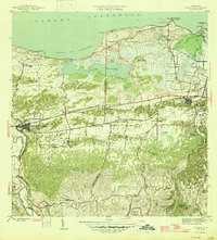
 1942 Manati1942 Print · USGSThe northern coast of Puerto Rico during the early forties reveals a landscape of industrial sugar production and historic municipal centers. Genealogists and local historians can trace family roots through named settlements like Colonia El Pueblito or locate the historic Capilla de la Virgen del Carmen near Manati.2 unique versions available
 - 1946 Map of Corozal
 1946 Corozal1946 Print · USGSCorozal and the central highlands of Puerto Rico are captured here in the mid-forties, showing a landscape of steep ridges and deep river valleys. Genealogists and local historians can trace the foundations of local education and faith at sites like Escuela Segunda Unidad de Palmarejo and Iglesia La Milagrosa.3 unique versions available
 - 1946 Map of Ciales
 1946 Ciales1946 Print · USGSThe mountainous terrain of central Puerto Rico comes alive in this post-war survey of the river valleys and peaks. Genealogists can trace family connections to rural barrios and landmarks like Hacienda Maria, Iglesia San Antonio, or the Escuela Segunda Unidad de Pesas.
 - 1946 Map of Manati
 1946 Manati1946 Print · USGSThe coastal plains and karst hills of northern Puerto Rico are captured here during the mid-forties, highlighting a landscape dominated by sugar estates and rail. Genealogists and historians can trace the local plantation economy through named sites like Colonia Coto Norte and the path of the American Railroad of Porto Rico.3 unique versions available
 - 1947 Map of Corozal SO
 1947 Corozal SO1947 Print · USGSCorozal and its surrounding municipalities are shown in high detail during the late 1940s, mapping the complex interior highlands of Puerto Rico. Local researchers can locate rural homesteads and institutional landmarks like Iglesia La Milagrosa and the Escuela Vocacional Dr José Padín.
 - 1947 Map of Ciales SO
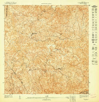
 1947 Ciales SO1947 Print · USGSHigh in the interior of Puerto Rico during the 1940s, this survey captures the convergence of three municipalities along the Rio Grande de Manati. Local researchers can trace old mountain routes near the Escuela Segunda Unidad de Pesas and Capilla del Carmen.
 - 1947 Map of Corozal NO
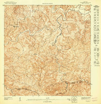
 1947 Corozal NO1947 Print · USGSThe Puerto Rican highlands around Corozal are captured in the late 1940s, showing a rural landscape dominated by steep ridges and winding rivers. Researchers can locate specific community institutions such as the Iglesia de la Inmaculada Concepción and the Escuela Segunda Unidad Nicolás Rodríguez Padilla.
 - 1947 Map of Ciales NO
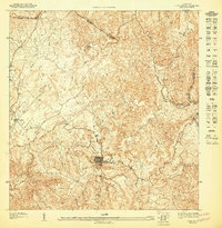
 1947 Ciales NO1947 Print · USGSThe Puerto Rican highlands around Ciales appear in remarkable detail during the 1940s as the river-valley economy flourished. Genealogists and researchers can trace local landmarks like Hacienda Maria, the Iglesia San Antonio, and the settlement of Hato Viejo.
 - 1947 Map of Ciales SE
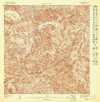 1947 Ciales SE1947 Print · USGSCentral Puerto Rico's interior highlands are mapped here during the late 1940s, showing the complex river systems and municipal boundaries of the day. Researchers can trace local limits between Morovis and Ciales along the Rio Grande De Manati.
 - 1947 Map of Ciales NE
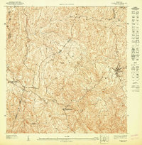
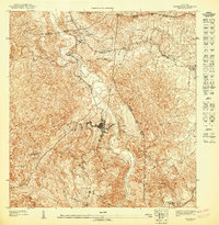
 1947 Ciales NE1947 Print · USGSMorovis and its surrounding valleys are captured here in detail during the late 1940s. Genealogists and researchers can trace the roads connecting the town center to Torrecillas, locating landmarks like the Iglesia del Niño Jesus and the banks of the Rio Indio.
End of results
Showing maps 1-10 of 10
Frequently asked questions
- What are the different types of historical maps available for Morovis?
- What is the oldest map of Morovis?
- Where can I purchase historical maps of Morovis for my home or office?
- Where can I download high-res historical maps of Morovis?
- Are there historical topographic maps available for Morovis?
- Is there historical aerial imagery available for Morovis?
- Where are historical maps of Morovis sourced from?