Old Maps of Orocovis for Genealogy
Trace your family roots with 49 historic maps of Orocovis. These high-res maps reveal old neighborhoods, homesites, landmarks, and streets — helping you uncover where your ancestors lived and how the area evolved over time.
- Explore historic neighborhoods: Identify where your relatives may have lived in the 1800s or 1900s.
- Compare maps over time: Trace the changes in streets, buildings, and landmarks for multi-generational research.
- Perfect for genealogy & ancestry research: Used by family historians and researchers to map out lineage and migration.
These maps are an incredible resource for exploring your personal connection to Orocovis's past.
Orocovis maps
(49)- 1946 Map of Corozal
 1946 Corozal1946 Print · USGSCorozal and the central highlands of Puerto Rico are captured here in the mid-forties, showing a landscape of steep ridges and deep river valleys. Genealogists and local historians can trace the foundations of local education and faith at sites like Escuela Segunda Unidad de Palmarejo and Iglesia La Milagrosa.3 unique versions available
 - 1946 Map of Barranquitas
 1946 Barranquitas1946 Print · USGSCentral Puerto Rico during the mid-1940s reveals a landscape of high-elevation settlements and mountain agriculture. Trace rural family roots at Hacienda Córcega or through numerous local schools like Escuela Segunda Unidad de Botijas No 2.3 unique versions available
 - 1946 Map of Ciales
 1946 Ciales1946 Print · USGSThe mountainous terrain of central Puerto Rico comes alive in this post-war survey of the river valleys and peaks. Genealogists can trace family connections to rural barrios and landmarks like Hacienda Maria, Iglesia San Antonio, or the Escuela Segunda Unidad de Pesas.
 - 1946 Map of Jayuya
 1946 Jayuya1946 Print · USGSThe high peaks and agricultural estates of the Cordillera Central are shown in detail during the 1940s. Genealogists and historians can locate numerous family haciendas like Hacienda Gripina, the Central Santa Barbara mill, and the summit of Cerro de Punta.3 unique versions available
 - 1946 Map of Florida
 1946 Florida1946 Print · USGSFlorida and the surrounding highlands of Puerto Rico are shown here in the 1940s, revealing a landscape of traditional mountain estates and rural schools. Genealogists and historians can trace family-named sites like Hacienda Las Abras and Hacienda Aldea or find local landmarks like the Escuela Segunda Unidad de Mameyes.3 unique versions available
 - 1946 Map of Orocovis
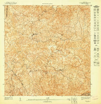
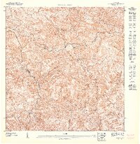
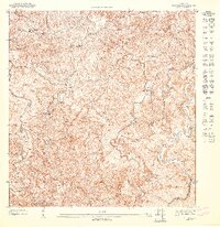
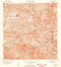
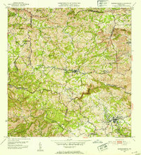
 1946 Orocovis1946 Print · USGSThe Puerto Rican highlands are captured here in the mid-1940s, showing the ridge-top settlements and deep river valleys of the interior. Researchers can trace the rural infrastructure of the era, from the Lago de Matrullas reservoir to landmarks like the Capilla de San José and Hacienda Limón.3 unique versions available
 - 1947 Map of Corozal SO
 1947 Corozal SO1947 Print · USGSCorozal and its surrounding municipalities are shown in high detail during the late 1940s, mapping the complex interior highlands of Puerto Rico. Local researchers can locate rural homesteads and institutional landmarks like Iglesia La Milagrosa and the Escuela Vocacional Dr José Padín.
 - 1947 Map of Orocovis NE
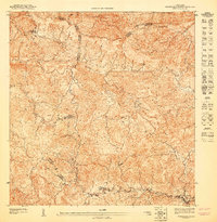
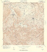
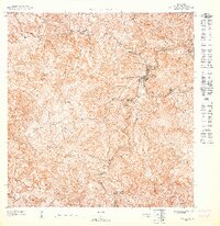 1947 Orocovis NE1947 Print · USGSOrocovis and the surrounding highlands are captured in the mid-1940s before the expansion of modern mountain infrastructure. Researchers can trace rural life through landmarks like Cerro Pío, the Escuela Salto, and the winding course of the Río Orocovis.
 - 1947 Map of Ciales SO
 1947 Ciales SO1947 Print · USGSHigh in the interior of Puerto Rico during the 1940s, this survey captures the convergence of three municipalities along the Rio Grande de Manati. Local researchers can trace old mountain routes near the Escuela Segunda Unidad de Pesas and Capilla del Carmen.
 - 1947 Map of Orocovis SO
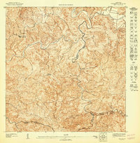
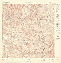
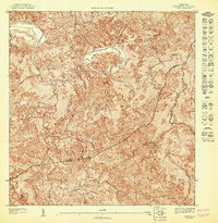
 1947 Orocovis SO1947 Print · USGSThe interior highlands of central Puerto Rico are captured here in the late 1940s as the region's rural infrastructure began to modernize. Researchers can trace family sites near Villalba or locate landmarks like Hacienda Limón and the Capilla de San José.
 - 1947 Map of Orocovis SE
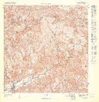
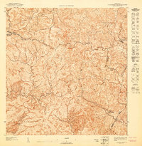
 1947 Orocovis SE1947 Print · USGSThe central mountains of Puerto Rico in the mid-1940s are shown here as a landscape of steep ridges and rural watersheds. Genealogists and historians can trace family locations along the Rio Toa Vaca, the heights of Cerro El Malo, and the trails of the Cordillera Central.
 - 1947 Map of Orocovis NO
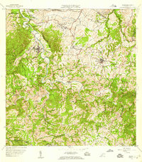
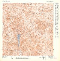 1947 Orocovis NO1947 Print · USGSThe Puerto Rican highlands in the mid-1940s are defined here by the steep peaks of the Cordillera Central and the waters of Lago de Matrullas. Researchers can trace old mountain trails and municipal boundaries near Cerro Mime, Peña La Francia, and the winding Río Bauta.
 - 1947 Map of Jayuya NE
 1947 Jayuya NE1947 Print · USGSThe central mountains of Puerto Rico are depicted in detail just after the war, showing the convergence of Ciales and Jayuya. Genealogists can trace family footprints near Casa Blanca, Coabey, and the ridges surrounding Tres Picachos.
 - 1947 Map of Jayuya SE
 1947 Jayuya SE1947 Print · USGSThe high interior of Puerto Rico is captured here in the 1940s, showcasing the agricultural and hydroelectric development across the Cordillera Central. Researchers can locate historic family estates like Hacienda El Semil and trace the early power grid at Planta Hydroelectrica Toro Negro No 2.
 - 1947 Map of Florida SE
 1947 Florida SE1947 Print · USGSThe interior of Ciales in the late 1940s reveals a traditional highland landscape of coffee estates and mountain trails. Family researchers can locate historic estates like Hacienda Peñonales and Hacienda Colón, or trace the winding course of the Río Yunes.
 - 1947 Map of Barranquitas NO
 1947 Barranquitas NO1947 Print · USGSThe central cordillera of Puerto Rico comes alive in the 1940s, showing a landscape defined by deep river valleys and high peaks. Genealogists and historians can trace local rural life through the Escuela Segunda Unidad de Palo Hincado and La Torrecilla.
 - 1947 Map of Ciales SE
 1947 Ciales SE1947 Print · USGSCentral Puerto Rico's interior highlands are mapped here during the late 1940s, showing the complex river systems and municipal boundaries of the day. Researchers can trace local limits between Morovis and Ciales along the Rio Grande De Manati.
 - 1947 Map of Barranquitas SO
 1947 Barranquitas SO1947 Print · USGSThe rural highlands of Coamo and Barranquitas are captured here in the late 1940s as agricultural life centered around family estates and mountain schools. Researchers can trace the grounds of Hacienda Córcega and locate regional landmarks like Cerro Pulguillas or the Escuela Segunda Unidad de Helechal.
 - 1952 Map of Jayuya, 1953 Print
 1952 Jayuya1953 Print · USGSThe Cordillera Central mountains surrounding Jayuya appear in high detail during the early fifties, showing the region's dense network of agricultural estates. Genealogists and historians can trace family-named lands like Hacienda Gripiña and Hacienda Santa Rosa near the heights of Cerro de Punta.2 unique versions available
 - 1952 Map of Florida, 1953 Print
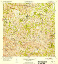
 1952 Florida1953 Print · USGSThe agricultural heartland of northern Puerto Rico comes alive in the early fifties, showing a dense landscape of historic haciendas and rural schools. Genealogists can trace family connections to estates like Hacienda San José or Hacienda Piedra Gorda and early social centers like the Escuela Segunda Unidad de Frontón.2 unique versions available
 - 1952 Map of Orocovis, 1953 Print
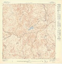
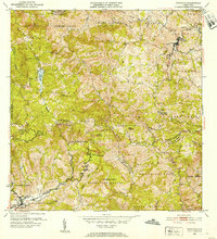 1952 Orocovis1953 Print · USGSThe central Puerto Rican highlands appear in great detail during the early fifties, documenting the complex network of barrio boundaries and mountain roads. Genealogists and historians can trace local landmarks like Hacienda Limon, the Capilla de San Jose, and the Escuela Segunda Unidad de Bauta.2 unique versions available
 - 1953 Map of Ciales
 1953 Ciales1953 Print · USGSThe northern foothills of central Puerto Rico are captured here in the mid-fifties, showing the developed town centers of Ciales and Morovis. Genealogists can trace local landmarks like Hacienda Maria, the Iglesia del Nino Jesus, and the Escuela Segunda Unidad de Pesas.
 - 1953 Map of Corozal
 1953 Corozal1953 Print · USGSCentral Puerto Rico's interior is captured here in the early fifties as the town of Corozal expanded its infrastructure. Genealogists and historians can locate specific landmarks like the Acueducto de Corozal, Iglesia La Milagrosa, and numerous localized school units.2 unique versions available
 - 1953 Map of Barranquitas, 1954 Print
 1953 Barranquitas1954 Print · USGSThe heart of the Puerto Rican interior is revealed in the early fifties as a landscape of mountain barrios and growing towns. Researchers can locate dozens of rural landmarks, from Hacienda Córcega to numerous schools like Escuela Segunda Unidad de Botijas No. 2.2 unique versions available
 - 1957 Map of Ciales, 1959 Print
 1957 Ciales1959 Print · USGSIn the late fifties, the central highlands of Puerto Rico maintained a landscape of steep coffee-country peaks and river-bound barrios. Researchers can trace local genealogy through rural schools like Escuela Barahona and parish sites such as Iglesia San Antonio.5 unique versions available
Showing maps 1-25 of 49
Frequently asked questions
- What are the different types of historical maps available for Orocovis?
- What is the oldest map of Orocovis?
- Where can I purchase historical maps of Orocovis for my home or office?
- Where can I download high-res historical maps of Orocovis?
- Are there historical topographic maps available for Orocovis?
- Is there historical aerial imagery available for Orocovis?
- Where are historical maps of Orocovis sourced from?