Old Maps of Playa, Ponce for Academic Research
Study the evolution of Playa with 17 high-resolution historic maps. Whether you're teaching, researching, or modeling changes in land use, these maps provide essential visual documentation of urban, environmental, and geographic change.
- Analyze long-term change: Track patterns in development, transportation, and natural features.
- Ideal for environmental or urban studies: Support academic projects with primary historical map data.
- Use in the classroom or lab: Educators and researchers rely on these maps to bring historical context to life.
These maps are a powerful tool for teaching, research, and visualizing how Playa has changed over the decades.
Playa, Ponce maps
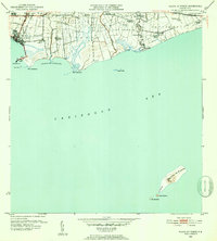
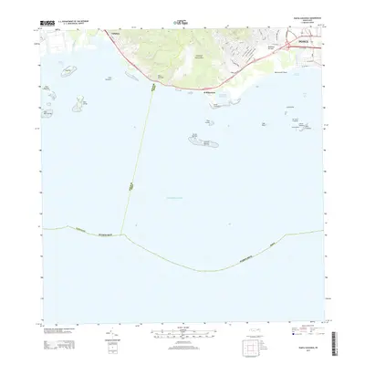
(17)- 1945 Map of Playa De Ponce
 1945 Playa De Ponce1945 Print · USGSThe coastal sugar economy of southern Puerto Rico is on full display here during the mid-1940s. Genealogists and industrial historians can trace the operations of Central Constancia and the rail lines of the American Railroad of Puerto Rico.3 unique versions available
 - 1946 Map of Punta Cuchara
 1946 Punta Cuchara1946 Print · USGSThe southern coast of Puerto Rico appears here during the mid-1940s, showing the vital maritime and rail corridors near Ponce. Researchers can locate the American Railroad line and trace agricultural estates like Hacienda Matilde or the old Faro on Cayo Cardona.3 unique versions available
 - 1947 Map of Punta Gughara NE
 1947 Punta Gughara NE1947 Print · USGSThe southern coast of Puerto Rico is captured here in the late 1940s, showing the agricultural and maritime character of the area around Ponce. Researchers can trace the layout of Hacienda Matilde, locate the coastal Faro, and explore the wetlands of Laguna de las Salinas.
 - 1947 Map of Playa De Ponce NO
 1947 Playa De Ponce NO1947 Print · USGSThe south coast of Puerto Rico is shown in the mid-1940s as an engine of the sugar industry and maritime trade. Genealogists and researchers can trace family lands at Hacienda Reparada or follow the shoreline from the Muelle de Ponce to Pta Cabullón.
 - 1952 Map of Playa De Ponce
 1952 Playa De Ponce1952 Print · USGSThe Puerto Rican coast near Ponce comes alive in the early fifties, showing a landscape of sugar centrales and coastal haciendas. Trace the sugar economy through Central Constancia and find offshore landmarks like the Faro on Isla Caja de Muertos.2 unique versions available
 - 1952 Map of Punta Cuchara
 1952 Punta Cuchara1952 Print · USGSThe southern coast of Puerto Rico appears here at mid-century as a landscape of coastal railroads and colonial estates. Local historians can trace the Porto Rico American Railroad and identify old sites like Hacienda Matilde and Tallaboa Poniente.2 unique versions available
 - 1958 Map of Playa De Ponce, 1961 Print
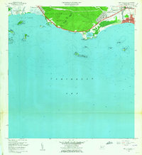
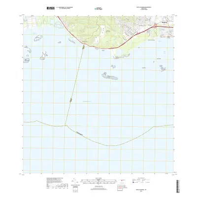
 1958 Playa De Ponce1961 Print · USGSThe southern coast of Puerto Rico is captured here in the late fifties, showcasing the intricate network of riverside haciendas and the bustling waterfront at Playa de Ponce. Genealogists can trace family lands like Hacienda Serrano or locate the historic Faro and the distant Isla Caja de Muertos.
 - 1958 Map of Punta Cucharas, 1961 Print
 1958 Punta Cucharas1961 Print · USGSThe southern coast of Puerto Rico is captured here in the late fifties as the harbor at Playa de Ponce thrived. Researchers can trace the path of the Ferrocarril de Puerto Rico and locate local landmarks like Hacienda Matilde and Cayo Cardona.2 unique versions available
 - 1962 Map of Punta Cucharas, 1964 Print
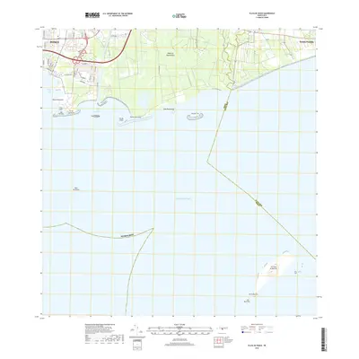
 1962 Punta Cucharas1964 Print · USGSThe southern coast of Puerto Rico comes into focus during the early sixties as urban expansion reaches toward the sea. Researchers can trace the heritage of Playa de Ponce, the site of Hacienda Matilde, and the route of the Antigua Vía del Ferrocarril.4 unique versions available
 - 1962 Map of Playa De Ponce, 1964 Print
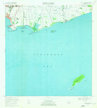
 1962 Playa De Ponce1964 Print · USGSThe Caribbean coast of southern Puerto Rico comes alive in this early 1960s survey, highlighting the bustling maritime hub at Playa de Ponce. Researchers can trace the waterfront around the Muelle de Ponce or explore offshore landmarks like Isla Caja de Muertos.
 - 1970 Map of Playa De Ponce, 1972 Print
 1970 Playa De Ponce1972 Print · USGSThe southern coast of Puerto Rico is captured here in the early seventies as industrial port activity and coastal barrios expanded. Genealogists and historians can trace family locations in Canas Urbano or offshore landmarks like Isla Caja de Muertos and Cayo Gata.3 unique versions available
 - 2013 Map of Playa De Ponce, 2013 Print
 2013 Playa De Ponce2013 Print · USGSCovers Playa, including El Polvorín, Manzanilla, and other nearby areas
 - 2013 Map of Punta Cucharas, 2013 Print
 2013 Punta Cucharas2013 Print · USGSCovers Playa, including Villa Laramia, Ponce, and other nearby areas
 - 2018 Map of Playa De Ponce, 2018 Print
 2018 Playa De Ponce2018 Print · USGSCovers Playa, including El Polvorín, Manzanilla, and other nearby areas
 - 2018 Map of Punta Cucharas, 2018 Print
 2018 Punta Cucharas2018 Print · USGSCovers Playa, including Villa Laramia, Ponce, and other nearby areas
 - 2024 Map of Playa De Ponce, 2024 Print
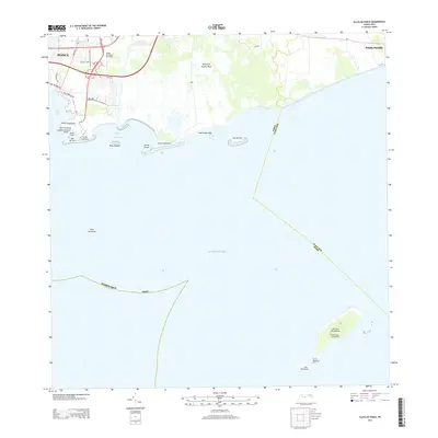
 2024 Playa De Ponce2024 Print · USGSThe southern coast of Puerto Rico is captured here in contemporary detail, showing the integration of maritime industry and urban growth. Researchers can trace the layout of Playa de Ponce or locate landmarks like the Muelle de Ponce and offshore Isla Caja de Muertos.
 - 2024 Map of Punta Cucharas, 2024 Print
 2024 Punta Cucharas2024 Print · USGSThe coast of Ponce and the southern shoreline of the island are captured here in the contemporary era. Researchers can trace the layout of Playa de Ponce, find the Cementerio Municipal de la Playa, or locate the Instituto de Puerto Rico.
End of results
Showing maps 1-17 of 17
Frequently asked questions
- What are the different types of historical maps available for Playa?
- What is the oldest map of Playa?
- Where can I purchase historical maps of Playa for my home or office?
- Where can I download high-res historical maps of Playa?
- Are there historical topographic maps available for Playa?
- Is there historical aerial imagery available for Playa?
- Where are historical maps of Playa sourced from?