1940s Maps of Villa Flores, Sabana Grande
Explore 2 historic maps of Villa Flores from the 1940s. These maps offer a rare glimpse into what life looked like during the 1940s — showing old roads, neighborhoods, homes, and landmarks that have changed or disappeared over time.
Whether you're researching your family's past, planning a metal detecting trip, or studying how Villa Flores's landscape evolved across the 1940s, these high-resolution maps are a powerful tool for exploring the history of this region.
- Focus on a specific era: All maps on this page are from the 1940s, giving you a focused view of this time period.
- See what’s changed: Compare century-old streets, trails, and buildings to today's modern landscape using overlays and satellite layers.
- Research with precision: Use these maps for genealogy, historical research, land use analysis, or educational projects.
- View, download, or print: Maps are fully viewable online in high resolution, and can be downloaded or printed for your own records.
Start exploring Villa Flores's history through authentic maps from the 1940s. This is your window into the past.
Villa Flores, Sabana Grande maps
(2)- 1941 Map of Sabana Grande
 1941 Sabana Grande1941 Print · USGSSouthwest Puerto Rico in the late 1930s shows a landscape of rail-dependent agriculture and highland settlements. Researchers can trace the American Railroad of Porto Rico through stops at Estacion Limon and Fraternidad near the edge of the Laguna de Guanica.5 unique versions available
 - 1949 Map of Sabana Grande NO
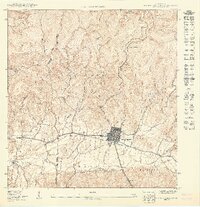 1949 Sabana Grande NO1949 Print · USGSThe town of Sabana Grande and its surrounding valleys are captured in the late 1940s as the local rail and agricultural systems shaped the landscape. Researchers can trace the path of the American Railroad of Porto Rico and locate local landmarks like the Escuela Hostos or Cementerio Municipal.
End of results
Showing maps 1-2 of 2
Frequently asked questions
- What are the different types of historical maps available for Villa Flores?
- What is the oldest map of Villa Flores?
- Where can I purchase historical maps of Villa Flores for my home or office?
- Where can I download high-res historical maps of Villa Flores?
- Are there historical topographic maps available for Villa Flores?
- Is there historical aerial imagery available for Villa Flores?
- Where are historical maps of Villa Flores sourced from?