1950s Maps of San Germán
Explore 8 historic maps of San Germán from the 1950s. These maps offer a rare glimpse into what life looked like during the 1950s — showing old roads, neighborhoods, homes, and landmarks that have changed or disappeared over time.
Whether you're researching your family's past, planning a metal detecting trip, or studying how San Germán's landscape evolved across the 1950s, these high-resolution maps are a powerful tool for exploring the history of this region.
- Focus on a specific era: All maps on this page are from the 1950s, giving you a focused view of this time period.
- See what’s changed: Compare century-old streets, trails, and buildings to today's modern landscape using overlays and satellite layers.
- Research with precision: Use these maps for genealogy, historical research, land use analysis, or educational projects.
- View, download, or print: Maps are fully viewable online in high resolution, and can be downloaded or printed for your own records.
Start exploring San Germán's history through authentic maps from the 1950s. This is your window into the past.
San Germán maps
(8)- 1950 Map of Rosario SO
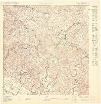 1950 Rosario SO1950 Print · USGSWestern Puerto Rico at the midpoint of the century shows a landscape of mountain forests and sugar-related rail infrastructure. Genealogists and historians can locate rural centers like Rosario, find family landmarks such as Desvío Eureka, and trace early sites like the Hospital de Tuberculosis.
 - 1950 Map of Rosario SE
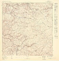 1950 Rosario SE1950 Print · USGSSan Germán and Maricao are shown here at mid-century, defined by steep mountain barrios and traditional agricultural estates. Genealogists and historians can trace family locations near Hacienda Córcega, the settlement of Las Vegas, and the watershed of the Río Rosario.
 - 1950 Map of San German NE
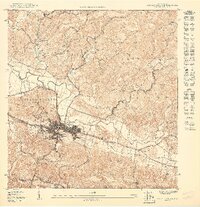 1950 San German NE1950 Print · USGSSan Germán and its surrounding highlands are captured here at mid-century, showing the town's expansion and its vital transportation links. Researchers can trace the path of the American RR and locate historical sites like the Instituto Politecnico and Lomas de Santa Marta.
 - 1950 Map of San German NO
 1950 San German NO1950 Print · USGSSouthwestern Puerto Rico at mid-century reveals a landscape of massive sugar haciendas and the early expansion of modern infrastructure. Genealogists and historians can trace the foundations of local barrios through sites like Central Eureka and the Escuela Segunda Unidad de Sabana Eneas.
 - 1952 Map of Maricao, 1953 Print
 1952 Maricao1953 Print · USGSWestern Puerto Rico’s coffee country is mapped in the early fifties, showing a landscape defined by traditional haciendas and emerging mid-century infrastructure. Genealogists and historians can trace family-named estates like Hacienda Lealtad and Hacienda Santa Rita alongside landmarks like the Criadero Insular de Peces.2 unique versions available
 - 1955 Map of Rosario, 1958 Print
 1955 Rosario1958 Print · USGSMid-century San Germán and Maricao are shown here during a time when the highland economy still revolved around traditional haciendas. Genealogists and historians can locate family estates like Hacienda Juanita and community centers such as Rosario or the Iglesia de San Jose.
 - 1956 Map of Sabana Grande, 1959 Print
 1956 Sabana Grande1959 Print · USGSSabana Grande and the surrounding mountain barrios are shown here in the mid-fifties, just as the valley irrigation systems were transforming the landscape. Trace old community roots at the Iglesia de Sagrada Corazon de Jesus or along the Antigua Via del Ferrocarril.
 - 1957 Map of San German, 1959 Print
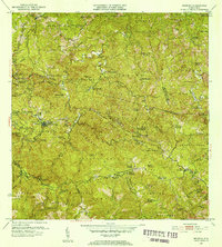
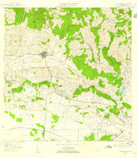
 1957 San German1959 Print · USGSSan Germán and the surrounding agricultural valleys are captured in the late fifties, showing the transition from traditional rail to modern infrastructure. Researchers can trace historic sugar haciendas like Hacienda Julia or locate local landmarks like the Instituto Politécnico and Laguna Cartagena.
End of results
Showing maps 1-8 of 8
Frequently asked questions
- What are the different types of historical maps available for San Germán?
- What is the oldest map of San Germán?
- Where can I purchase historical maps of San Germán for my home or office?
- Where can I download high-res historical maps of San Germán?
- Are there historical topographic maps available for San Germán?
- Is there historical aerial imagery available for San Germán?
- Where are historical maps of San Germán sourced from?