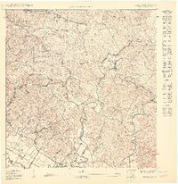
1950 Map of Rosario SO
USGS Topo · Published 1950About this map
The Bosque Insular de Maricao borders the rugged eastern edge of this 1:10,000 scale survey, where the topography transitions into the agricultural and residential landscape of western Puerto Rico. Local religious and social life is anchored by landmarks such as the Iglesia de San José, Capilla de Santa Ana, and Capilla de la Milagrosa, which served the rural barrios of Rosario, Malezas, and Benavente.
Find a feature on this map
30 named features on this map. Tap any name to fly to it.
Don’t see what you’re looking for? This feature index may not catch every label — zoom into the map to look around manually.
Map Details
Editions of this 1950 Rosario SO Map
This is the sole edition of this map. No revisions or reprints were ever made.
Other maps of this area

1935 · Puerto Real
USGS Topo · 1:25,000

1937 · San German
USGS Topo · 1:25,000

1937 · Puerto Real
USGS Topo · 1:25,000

1939 · Mayaguez
USGS Topo · 1:30,000

1941 · San German
USGS Topo · 1:30,000

1941 · Puerto Real
USGS Topo · 1:30,000

1941 · Rosario
USGS Topo · 1:30,000

1942 · Rosario
USGS Topo · 1:30,000
1947 · Mayaguez
USGS Topo · 1:30,000
1949 · Puerto Real NE
USGS Topo · 1:10,000
Featured Places
- Sector Los Limones, Mayagüez
- Sector Plan Bonito, Hormigueros
- Sector Punto Cubano, Hormigueros
- Urb. Jdn. de la Casona, Hormigueros
- Urb. Paseo Los Peregrinos, Hormigueros