1950s Maps of Pulguero, San Juan
Explore 2 historic maps of Pulguero from the 1950s. These maps offer a rare glimpse into what life looked like during the 1950s — showing old roads, neighborhoods, homes, and landmarks that have changed or disappeared over time.
Whether you're researching your family's past, planning a metal detecting trip, or studying how Pulguero's landscape evolved across the 1950s, these high-resolution maps are a powerful tool for exploring the history of this region.
- Focus on a specific era: All maps on this page are from the 1950s, giving you a focused view of this time period.
- See what’s changed: Compare century-old streets, trails, and buildings to today's modern landscape using overlays and satellite layers.
- Research with precision: Use these maps for genealogy, historical research, land use analysis, or educational projects.
- View, download, or print: Maps are fully viewable online in high resolution, and can be downloaded or printed for your own records.
Start exploring Pulguero's history through authentic maps from the 1950s. This is your window into the past.
Pulguero, San Juan maps
(2)- 1950 Map of San Juan NE
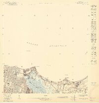 1950 San Juan NE1950 Print · USGSThe San Juan coastline and its expanding eastern suburbs are captured here at a pivotal moment of development. Trace the early footprint of the Aeropuerto Internacional and find local landmarks like Colegio del Sagrado Corazón or the Cementerio Buxeda.
 - 1957 Map of San Juan, 1959 Print
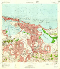 1957 San Juan1959 Print · USGSSan Juan and its surrounding barrios are seen here in the midst of mid-century modernization, from the old city walls to the emerging international airport. Genealogists and historians can locate family sites across Santurce, the grounds of the Universidad de Puerto Rico, and historic landmarks like La Fortaleza.
End of results
Showing maps 1-2 of 2
Frequently asked questions
- What are the different types of historical maps available for Pulguero?
- What is the oldest map of Pulguero?
- Where can I purchase historical maps of Pulguero for my home or office?
- Where can I download high-res historical maps of Pulguero?
- Are there historical topographic maps available for Pulguero?
- Is there historical aerial imagery available for Pulguero?
- Where are historical maps of Pulguero sourced from?