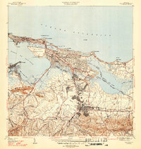
1950 Map of San Juan NE
USGS Topo · Published 1950About this map
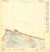
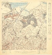
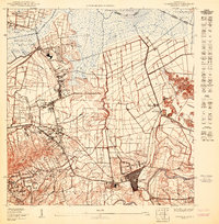
The growing urban infrastructure of San Juan and the adjacent Municipio de Carolina are documented in this mid-century survey, highlighted by the massive Aeropuerto Internacional (Proyecto) development. This coastal corridor shows a dense transition from the city blocks of Santa Teresita and Las Casas toward the more open terrain of Cangrejo Arriba. Several distinct local sites are clearly marked, including the Colegio del Sagrado Corazón and a cluster of burial grounds such as the Cementerio Memorial de Fourier and Cementerio Buxeda. The coastline is defined by prominent geographical features like Isla Verde and Pta Las Marías, while the inland landscape is shaped by the Laguna Los Corozos. Key transportation and communication markers include Camino Loiza and the Antenas de Radio WNEL, showing how the metropolitan area was expanding along the Océano Atlántico at this time.
Find a feature on this map
25 named features on this map. Tap any name to fly to it.
Don’t see what you’re looking for? This feature index may not catch every label — zoom into the map to look around manually.
Map Details
Editions of this 1950 San Juan NE Map
This is the sole edition of this map. No revisions or reprints were ever made.
Other maps of this area

1940 · Carolina
USGS Topo · 1:30,000

1941 · San Juan
USGS Topo · 1:30,000

1941 · Carolina
USGS Topo · 1:30,000

1947 · Carolina
USGS Topo · 1:30,000
1947 · San Juan
USGS Topo · 1:30,000
1949 · San Juan
USGS Topo · 1:30,000
1950 · San Juan SE
USGS Topo · 1:10,000
1950 · Carolina NO
USGS Topo · 1:10,000
1950 · San Juan SO
USGS Topo · 1:10,000
1950 · Carolina SO
USGS Topo · 1:10,000