1950 Map of San Juan SE
USGS Topo · Published 1950About this map
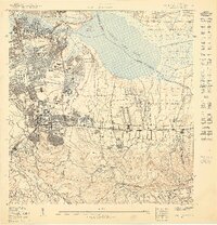
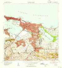
The growing urbanization of the Río Piedras district and the surrounding Universidad sector characterizes this mid-century period in Puerto Rico. The map illustrates a transitional landscape where the established campus of the Universidad de Puerto Rico and neighborhoods like Hato Rey and Hyde Park meet expansive undeveloped tracts. A significant geographic focal point is the Laguna San José, which is bordered by a planned Aeropuerto Internacional (Proyecto) and a Reservación Naval near Cangrejo Arriba.
Find a feature on this map
59 named features on this map. Tap any name to fly to it.
Don’t see what you’re looking for? This feature index may not catch every label — zoom into the map to look around manually.
Map Details
Editions of this 1950 San Juan SE Map
This is the sole edition of this map. No revisions or reprints were ever made.
Other maps of this area

1940 · Carolina
USGS Topo · 1:30,000

1941 · San Juan
USGS Topo · 1:30,000

1941 · Carolina
USGS Topo · 1:30,000

1946 · Aguas Buenas
USGS Topo · 1:30,000

1946 · Gurabo
USGS Topo · 1:30,000

1947 · Carolina
USGS Topo · 1:30,000
1947 · Aguas Buenas NO
USGS Topo · 1:10,000
1947 · Aguas Buenas NE
USGS Topo · 1:10,000
1947 · San Juan
USGS Topo · 1:30,000
1949 · San Juan
USGS Topo · 1:30,000