
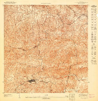
1947 Map of Aguas Buenas NO
USGS Topo · Published 1947About this map
Guaynabo serves as the primary urban hub in this mid-century topographic study, which captures the interior of Puerto Rico before the extensive suburban development of later decades. The landscape is defined by the winding course of the Rio Guaynabo and the prominent Cerro Magueyes, with several small settlements such as La Esperanza and El Murao dotting the mountainous terrain. The map provides a detailed view of the municipal boundary between the Municipio de Guaynabo and the Municipio de Rio Piedras. Significant local landmarks include the Escuela Segunda Unidad de Caimito and a Cantera (quarry), illustrating the educational and industrial infrastructure of the era. The dense network of trails and secondary roads connecting places like La Muda and El Laberinto reflects a rural economy still largely dependent on local topography and traditional routes.
Find a feature on this map
13 named features on this map. Tap any name to fly to it.
Don’t see what you’re looking for? This feature index may not catch every label — zoom into the map to look around manually.
Map Details
Editions of this 1947 Aguas Buenas NO Map
This is the sole edition of this map. No revisions or reprints were ever made.
Other maps of this area

1941 · Bayamon
USGS Topo · 1:30,000

1941 · San Juan
USGS Topo · 1:30,000

1946 · Aguas Buenas
USGS Topo · 1:30,000

1946 · Naranjito
USGS Topo · 1:30,000
1947 · Naranjito SE
USGS Topo · 1:10,000

1947 · Bayamon
USGS Topo · 1:30,000
1947 · Naranjito NE
USGS Topo · 1:10,000
1947 · Aguas Buenas NE
USGS Topo · 1:10,000
1947 · Aguas Buenas SE
USGS Topo · 1:10,000
1947 · Aguas Buenas SO
USGS Topo · 1:10,000
Featured Places
- Guaynabo
- Sector Pizarro, Guaynabo
- Sector Hernández, Guaynabo
- Sector Cubitas, Guaynabo
- Sector Los Cancel, Guaynabo