1947 Map of Aguas Buenas NE
USGS Topo · Published 1947About this map
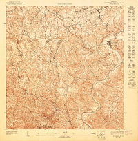
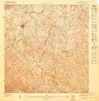
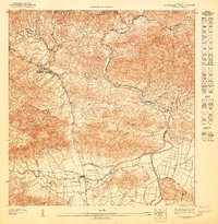
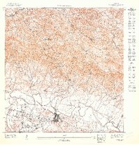
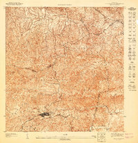
Trujillo Alto sits along a dramatic bend of the Río Grande de Loíza in this 1947 topographic study, showing the town before its mid-century expansion. The landscape is defined by a dense network of watercourses, including Quebrada Blasina and Quebrada Carraizo, which carve through the varied elevation leading up to Cerro Cupéy. This preliminary map documents a rural social infrastructure, noting the Escuela Segunda Unidad de Cupéy and the Leprocomio medical facility, which was a significant institutional presence in the region at the time.
Find a feature on this map
20 named features on this map. Tap any name to fly to it.
Don’t see what you’re looking for? This feature index may not catch every label — zoom into the map to look around manually.
Map Details
Editions of this 1947 Aguas Buenas NE Map
This is the sole edition of this map. No revisions or reprints were ever made.
Other maps of this area

1940 · Carolina
USGS Topo · 1:30,000

1941 · San Juan
USGS Topo · 1:30,000

1941 · Carolina
USGS Topo · 1:30,000

1946 · Aguas Buenas
USGS Topo · 1:30,000

1946 · Gurabo
USGS Topo · 1:30,000

1947 · Carolina
USGS Topo · 1:30,000
1947 · Aguas Buenas NO
USGS Topo · 1:10,000
1947 · Aguas Buenas SE
USGS Topo · 1:10,000
1947 · Gurabo SO
USGS Topo · 1:10,000
1947 · Aguas Buenas SO
USGS Topo · 1:10,000
Featured Places
- Trujillo Alto, Trujillo Alto
- Brisas de Carraízo, Trujillo Alto
- Estancias de Cupey, San Juan
- Sector Los Corujo, Trujillo Alto
- Reparto Cupesol, Trujillo Alto