1947 Map of Naranjito SE
USGS Topo · Published 1947About this map
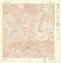
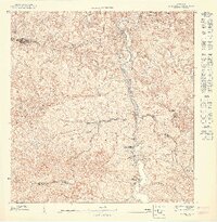
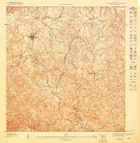
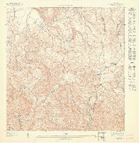
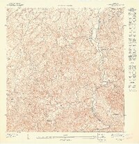
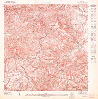
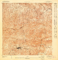
Río Bayamón snakes through the center of this 1947 landscape, defining a complex topography of deep ravines and rising peaks. This detailed study, commissioned by Orlando R. Méndez, captures the interior of Puerto Rico before significant modern development altered its rural character. The map identifies the Acueducto de San Juan, a critical piece of infrastructure situated along the riverbanks. Cultural life in these hills is anchored by several small congregations, including the Iglesia Evangelica and Iglesia Sagrado Corazon de Jesus. The terrain is marked by prominent elevations like Cerro La Peña and Cerro Mula, which dominate the local horizon. Countless waterways like Quebrada Chorreras and Quebrada Sonadora feed into the main river systems, illustrating the intricate drainage patterns of the region.
Find a feature on this map
25 named features on this map. Tap any name to fly to it.
Don’t see what you’re looking for? This feature index may not catch every label — zoom into the map to look around manually.
Map Details
Editions of this 1947 Naranjito SE Map
This is the sole edition of this map. No revisions or reprints were ever made.
Other maps of this area

1946 · Aguas Buenas
USGS Topo · 1:30,000

1946 · Comerio
USGS Topo · 1:30,000

1946 · Naranjito
USGS Topo · 1:30,000

1946 · Caguas
USGS Topo · 1:30,000
1947 · Naranjito SO
USGS Topo · 1:10,000
1947 · Aguas Buenas NO
USGS Topo · 1:10,000
1947 · Naranjito NO
USGS Topo · 1:10,000
1947 · Naranjito NE
USGS Topo · 1:10,000
1947 · Caguas NO
USGS Topo · 1:10,000
1947 · Aguas Buenas SO
USGS Topo · 1:10,000
Featured Places
- Sector Los Báez, Guaynabo
- Collores, Bayamón
- Sector El Tamarindo, Bayamón
- Sector Febus, Bayamón
- Sector Los Falcones, Bayamón