1970s Maps of Santa Isabel
Explore 4 historic maps of Santa Isabel from the 1970s. These maps offer a rare glimpse into what life looked like during the 1970s — showing old roads, neighborhoods, homes, and landmarks that have changed or disappeared over time.
Whether you're researching your family's past, planning a metal detecting trip, or studying how Santa Isabel's landscape evolved across the 1970s, these high-resolution maps are a powerful tool for exploring the history of this region.
- Focus on a specific era: All maps on this page are from the 1970s, giving you a focused view of this time period.
- See what’s changed: Compare century-old streets, trails, and buildings to today's modern landscape using overlays and satellite layers.
- Research with precision: Use these maps for genealogy, historical research, land use analysis, or educational projects.
- View, download, or print: Maps are fully viewable online in high resolution, and can be downloaded or printed for your own records.
Start exploring Santa Isabel's history through authentic maps from the 1970s. This is your window into the past.
Santa Isabel maps
(4)- 1970 Map of Salinas, 1972 Print
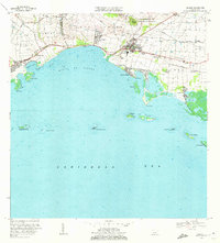 1970 Salinas1972 Print · USGSThe southern coast of Puerto Rico is captured here in the early seventies, detailing the transition from mountain foothills to the Caribbean. Trace historic family estates like Hacienda Carmen or explore coastal features like Mar Negro and the Aeropuerto de Salinas.4 unique versions available
 - 1972 Map of Coamo, 1973 Print
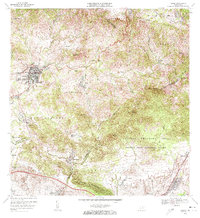 1972 Coamo1973 Print · USGSThe town of Coamo sits at the edge of the Cordillera Central in the early seventies, showing a landscape of traditional haciendas and modern military training grounds. Genealogists can locate family names and sites like Hacienda Buena Vista, San Diego, and the Escuela Federico Degetau.3 unique versions available
 - 1972 Map of Santa Isabel, 1973 Print
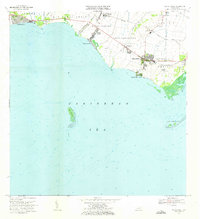 1972 Santa Isabel1973 Print · USGSThe southern coast of Puerto Rico is captured here in the early seventies, showing a landscape defined by sugar history and maritime activity. Researchers can locate family estates like Hacienda Florida, the old Estación Santa Isabel, and coastal landmarks like Cayo Berbería.2 unique versions available
 - 1972 Map of Rio Descalabrado, 1974 Print
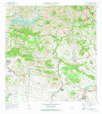 1972 Rio Descalabrado1974 Print · USGSSouthern Puerto Rico in the early seventies shows a transition from traditional sugarcane estates to modern infrastructure. Researchers can trace the boundaries of historic haciendas like Hacienda Amelia or locate the Fort Allen Naval Radio Station and Lago Coamo.4 unique versions available
End of results
Showing maps 1-4 of 4
Frequently asked questions
- What are the different types of historical maps available for Santa Isabel?
- What is the oldest map of Santa Isabel?
- Where can I purchase historical maps of Santa Isabel for my home or office?
- Where can I download high-res historical maps of Santa Isabel?
- Are there historical topographic maps available for Santa Isabel?
- Is there historical aerial imagery available for Santa Isabel?
- Where are historical maps of Santa Isabel sourced from?