1900s (20th Century) Maps of Jagüeyes, Vieques
Explore 2 historic maps of Jagüeyes from the 1900s (20th Century). These maps offer a rare glimpse into what life looked like during the 1900s — showing old roads, neighborhoods, homes, and landmarks that have changed or disappeared over time.
Whether you're researching your family's past, planning a metal detecting trip, or studying how Jagüeyes's landscape evolved across the 1900s, these high-resolution maps are a powerful tool for exploring the history of this region.
- Focus on a specific era: All maps on this page are from the 1900s, giving you a focused view of this time period.
- See what’s changed: Compare century-old streets, trails, and buildings to today's modern landscape using overlays and satellite layers.
- Research with precision: Use these maps for genealogy, historical research, land use analysis, or educational projects.
- View, download, or print: Maps are fully viewable online in high resolution, and can be downloaded or printed for your own records.
Start exploring Jagüeyes's history through authentic maps from the 1900s. This is your window into the past.
Jagüeyes, Vieques maps
(2)- 1943 Map of Island Of Vieques, 1946 Print
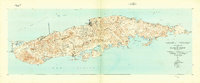 1943 Island Of Vieques1946 Print · USGSVieques during the 1940s reveals a maritime and agricultural landscape shaped by its barrios and coastal colonies. Trace the layout of Isabel Segunda, the agricultural sites at Colonia Lujan, and landmarks like Pta Mulas Faro.2 unique versions available
 - 1951 Map of Island Of Vieques
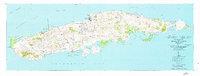 1951 Island Of Vieques1951 Print · USGSVieques is shown in detail during the early fifties, documenting the island's mid-century settlements and coastal geography. Researchers can trace the development of Isabel Segunda and find rural landmarks like Hacienda Arcadia and Colonia Luján.5 unique versions available
End of results
Showing maps 1-2 of 2
Frequently asked questions
- What are the different types of historical maps available for Jagüeyes?
- What is the oldest map of Jagüeyes?
- Where can I purchase historical maps of Jagüeyes for my home or office?
- Where can I download high-res historical maps of Jagüeyes?
- Are there historical topographic maps available for Jagüeyes?
- Is there historical aerial imagery available for Jagüeyes?
- Where are historical maps of Jagüeyes sourced from?