1950s Maps of Saint Croix District
Explore 3 historic maps of Saint Croix District from the 1950s. These maps offer a rare glimpse into what life looked like during the 1950s — showing old roads, neighborhoods, homes, and landmarks that have changed or disappeared over time.
Whether you're researching your family's past, planning a metal detecting trip, or studying how Saint Croix District's landscape evolved across the 1950s, these high-resolution maps are a powerful tool for exploring the history of this region.
- Focus on a specific era: All maps on this page are from the 1950s, giving you a focused view of this time period.
- See what’s changed: Compare century-old streets, trails, and buildings to today's modern landscape using overlays and satellite layers.
- Research with precision: Use these maps for genealogy, historical research, land use analysis, or educational projects.
- View, download, or print: Maps are fully viewable online in high resolution, and can be downloaded or printed for your own records.
Start exploring Saint Croix District's history through authentic maps from the 1950s. This is your window into the past.
Saint Croix District maps
(3)- 1958 Map of Christiansted, 1959 Print
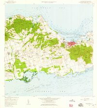 1958 Christiansted1959 Print · USGSSaint Croix's mid-century landscape is captured here just as the island began its modern growth phase. Researchers can trace the layout of Christiansted, locate family names among settlements like Sion Hill and Belvedere, and find landmarks like Kingshill Sch and the Alexander Hamilton Airport.6 unique versions available
 - 1958 Map of East Point, 1959 Print
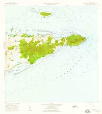 1958 East Point1959 Print · USGSThe eastern reaches of Saint Croix are captured in the late fifties, showing a landscape of traditional estates and rugged coastal topography. Genealogists can trace family landholdings and small settlements like All for the Better, Sallys Fancy, and Madame Carty.5 unique versions available
 - 1958 Map of Frederiksted, 1960 Print
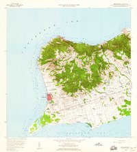 1958 Frederiksted1960 Print · USGSWestern Saint Croix is depicted in the late fifties, showcasing the transition from the waterfront at Frederiksted to inland estates. Trace historic place names and local infrastructure including Betty's Hope, the Fort Frederick Light, and Alexander Hamilton Airport.4 unique versions available
End of results
Showing maps 1-3 of 3
Frequently asked questions
- What are the different types of historical maps available for Saint Croix District?
- What is the oldest map of Saint Croix District?
- Where can I purchase historical maps of Saint Croix District for my home or office?
- Where can I download high-res historical maps of Saint Croix District?
- Are there historical topographic maps available for Saint Croix District?
- Is there historical aerial imagery available for Saint Croix District?
- Where are historical maps of Saint Croix District sourced from?