1970s Maps of Autaugaville, Alabama
Explore 2 historic maps of Autaugaville from the 1970s. These maps offer a rare glimpse into what life looked like during the 1970s — showing old roads, neighborhoods, homes, and landmarks that have changed or disappeared over time.
Whether you're researching your family's past, planning a metal detecting trip, or studying how Autaugaville's landscape evolved across the 1970s, these high-resolution maps are a powerful tool for exploring the history of this region.
- Focus on a specific era: All maps on this page are from the 1970s, giving you a focused view of this time period.
- See what’s changed: Compare century-old streets, trails, and buildings to today's modern landscape using overlays and satellite layers.
- Research with precision: Use these maps for genealogy, historical research, land use analysis, or educational projects.
- View, download, or print: Maps are fully viewable online in high resolution, and can be downloaded or printed for your own records.
Start exploring Autaugaville's history through authentic maps from the 1970s. This is your window into the past.
Autaugaville, AL maps
(2)- 1975 Map of Autaugaville NW, 1977 Print
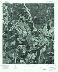 1975 Autaugaville NW1977 Print · USGSAutauga County's riverfront landscape is revealed in this mid-seventies survey of the rural South. Trace the relationship between the bend of the Alabama River and the settlement at Autaugaville through detailed aerial imagery.
 - 1975 Map of Autaugaville NE, 1977 Print
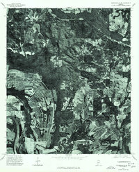 1975 Autaugaville NE1977 Print · USGSAutauga County's riverfront and timberlands are captured in detail during the mid-seventies, showing the rural landscape of central Alabama. Genealogists and local historians can trace the roads and fields surrounding the settlement of Forester and the banks of the Alabama River.
End of results
Showing maps 1-2 of 2
Top cities near Autaugaville
- Montgomery historical maps
- Prattville historical maps
- Pine Level historical maps
- White Hall historical maps
- Billingsley historical maps
- Lowndesboro historical maps
See more
Frequently asked questions
- What are the different types of historical maps available for Autaugaville?
- What is the oldest map of Autaugaville?
- Where can I purchase historical maps of Autaugaville for my home or office?
- Where can I download high-res historical maps of Autaugaville?
- Are there historical topographic maps available for Autaugaville?
- Is there historical aerial imagery available for Autaugaville?
- Where are historical maps of Autaugaville sourced from?