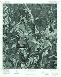
1975 Map of Autaugaville NW
USGS Topo · Published 1977About this map
The Alabama River winds through the southern portion of this landscape, its broad curves defining the agricultural and forested character of Autauga County in the mid-1970s. This orthophotobase map captures the dense patchwork of cultivated fields and timbered tracts surrounding the community of Autaugaville. By utilizing aerial imagery from late 1975, the survey provides a detailed visual record of the rural road network and land use patterns during this era. The transition between the high river bluffs and the level bottomlands illustrates the geographic factors that historically shaped settlement and farming in this river-oriented Alabama region.
Find a feature on this map
2 named features on this map. Tap any name to fly to it.
Don’t see what you’re looking for? This feature index may not catch every label — zoom into the map to look around manually.
Map Details
Editions of this 1975 Autaugaville NW Map
This is the sole edition of this map. No revisions or reprints were ever made.
Other maps of this area

1891 · Clanton
USGS Topo · 1:125,000

1953 · Montgomery
USGS Topo · 1:250,000

1956 · Montgomery
USGS Topo · 1:250,000

1957 · Montgomery
USGS Topo · 1:250,000

1957 · Autaugaville
USGS Topo · 1:62,500

1957 · Benton
USGS Topo · 1:62,500

1959 · Plantersville
USGS Topo · 1:62,500

1959 · Billingsley
USGS Topo · 1:62,500

1975 · Benton SE
USGS Topo · 1:24,000

1975 · Autaugaville SW
USGS Topo · 1:24,000