
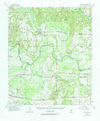
1957 Map of Autaugaville
USGS Topo · Published 1958About this map
The Alabama River carves a winding path through the heart of this central Alabama landscape, creating distinctive features like Dutch Bend and Dutch Island. On the northern banks, Autaugaville serves as a primary settlement, while south of the river, the rail-oriented economy is anchored by the Western Railway of Alabama. This rail corridor links smaller communities and stops such as St Clair (Lowndesboro Sta) and Burkville, illustrating the vital connection between agriculture and transport in the late 1950s.
Find a feature on this map
76 named features on this map. Tap any name to fly to it.
Don’t see what you’re looking for? This feature index may not catch every label — zoom into the map to look around manually.
Map Details
Editions of this 1957 Autaugaville Map
2 editions found
Other maps of this area

1891 · Clanton
USGS Topo · 1:125,000

1901 · Wetumpka
USGS Topo · 1:125,000

1903 · Wetumpka
USGS Topo · 1:125,000

1927 · Montgomery
USGS Topo · 1:48,000

1930 · Montgomery
USGS Topo · 1:62,500

1953 · Montgomery
USGS Topo · 1:250,000

1956 · Montgomery
USGS Topo · 1:250,000

1957 · Montgomery
USGS Topo · 1:250,000

1957 · Letohatchee
USGS Topo · 1:62,500

1957 · Benton
USGS Topo · 1:62,500