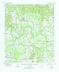
1957 Map of Autaugaville
USGS Topo · Published 1968About this map
Autaugaville and Lowndesboro anchor this mid-century look at the agricultural and riverine landscape spanning the Alabama River. The map reveals a transition between the uplands of Autauga County and the low-lying prairie of Lowndes County, where extensive wetlands like Sawyer Swamp and Honey Swamp define the terrain. The Western Railway of Alabama runs east-west through the southern half of the quadrangle, serving small stations and communities such as St Clair and Burkville.
Find a feature on this map
95 named features on this map. Tap any name to fly to it.
Don’t see what you’re looking for? This feature index may not catch every label — zoom into the map to look around manually.
Map Details
Editions of this 1957 Autaugaville Map
2 editions found
Other maps of this area

1891 · Clanton
USGS Topo · 1:125,000

1901 · Wetumpka
USGS Topo · 1:125,000

1903 · Wetumpka
USGS Topo · 1:125,000

1927 · Montgomery
USGS Topo · 1:48,000

1930 · Montgomery
USGS Topo · 1:62,500

1953 · Montgomery
USGS Topo · 1:250,000

1956 · Montgomery
USGS Topo · 1:250,000

1957 · Montgomery
USGS Topo · 1:250,000

1957 · Letohatchee
USGS Topo · 1:62,500

1957 · Autaugaville
USGS Topo · 1:62,500