
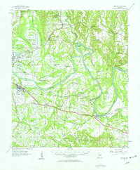
1957 Map of Benton
USGS Topo · Published 1958About this map
The Alabama River carves a winding path through this mid-century landscape, defining the borders between Dallas, Lowndes, and Autauga counties. The river's dramatic oxbows at Durant Bend and Days Bend create isolated pockets of bottomland, while the surrounding terrain is marked by extensive wetlands like Blue Girth Swamp and Beach Creek Swamp. In the west, the presence of Craig Air Force Base and Selfield Airport signals the era's military and aviation infrastructure, situated near the historic community of Brantley.
Find a feature on this map
75 named features on this map. Tap any name to fly to it.
Don’t see what you’re looking for? This feature index may not catch every label — zoom into the map to look around manually.
Map Details
Editions of this 1957 Benton Map
2 editions found
Other maps of this area

1891 · Clanton
USGS Topo · 1:125,000

1953 · Montgomery
USGS Topo · 1:250,000

1956 · Montgomery
USGS Topo · 1:250,000

1957 · Montgomery
USGS Topo · 1:250,000

1957 · Autaugaville
USGS Topo · 1:62,500

1957 · Carlowville
USGS Topo · 1:62,500

1957 · Braggs
USGS Topo · 1:62,500

1958 · Selma
USGS Topo · 1:62,500

1958 · Selma
USGS Topo · 1:24,000

1959 · Plantersville
USGS Topo · 1:62,500