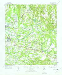
1957 Map of Benton
USGS Topo · Published 1958About this map
The Alabama River winds through the heart of this Central Alabama landscape, defining the borders between Dallas, Lowndes, and Autauga Counties. This mid-century survey captures a transition in transportation and land use, where the active Craig Air Force Base and Selfield Airport contrast with the rural network of schools and churches that sustained local communities. Significant educational landmarks like the Home Aid Industrial Sch and Tyler Union Sch appear alongside a high density of country churches, including New Brian Chapel and Sister Springs Ch.
Find a feature on this map
78 named features on this map. Tap any name to fly to it.
Don’t see what you’re looking for? This feature index may not catch every label — zoom into the map to look around manually.
Map Details
Editions of this 1957 Benton Map
2 editions found
Other maps of this area

1891 · Clanton
USGS Topo · 1:125,000

1953 · Montgomery
USGS Topo · 1:250,000

1956 · Montgomery
USGS Topo · 1:250,000

1957 · Montgomery
USGS Topo · 1:250,000

1957 · Autaugaville
USGS Topo · 1:62,500

1957 · Carlowville
USGS Topo · 1:62,500

1957 · Benton
USGS Topo · 1:62,500

1957 · Braggs
USGS Topo · 1:62,500

1958 · Selma
USGS Topo · 1:62,500

1958 · Selma
USGS Topo · 1:24,000