Old Maps of Hurricane, Alabama
Explore 15 old maps of Hurricane, spanning from 1941 to today. These high-resolution historic maps reveal how streets, neighborhoods, landmarks, and natural features evolved over time — perfect for genealogy, metal detecting, research, and local history exploration.
What you can do with these maps:
- See how Hurricane changed over time: Compare historical maps to modern-day views to trace roads, homesites, rail lines & more.
- View detailed metadata: Each map includes creators, publishers, year, scale, and archive source.
- Overlay maps with satellite & LiDAR: Visualize the past alongside modern tools to explore terrain & human change.
- Trusted historical sources: Maps sourced from the USGS, Library of Congress, and other archives.
- Access maps your way: View online, download high-res files, or order prints for personal or research use.
Start exploring old maps of Hurricane to uncover forgotten places, hidden landmarks, and the deep history beneath your feet.
Hurricane, AL maps
(15)- 1941 Map of Bay Minette, 1955 Print
 1941 Bay Minette1955 Print · USGSCoastal Alabama at the start of the 1940s is defined here by the complex river delta and the timber-rich uplands of Baldwin County. Genealogists and historians can trace old community centers like Whitehouse Forks, schools such as Stockton Sch, and the path of the Louisville and Nashville RR.2 unique versions available
 - 1942 Map of Hurricane
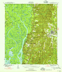
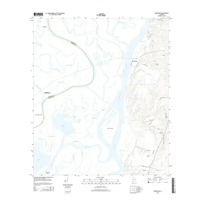
 1942 Hurricane1942 Print · USGSThe Mobile and Tensaw River deltas are captured here in the early 1940s, showing a world of tidal bayous and river landings. Genealogists and historians can locate the CIVIL WAR TRENCHES, family sites like Miller Cem, and old river stops including Steam Mill Landing.
 - 1943 Map of Hurricane
 1943 Hurricane1943 Print · USGSThe Mobile-Tensaw Delta in the early 1940s is a intricate network of bayous and river islands where the railroad meets the swamp. Researchers can locate family landmarks like Miller Cem, the Civil War Trenches, and the old Hurricane Sch.2 unique versions available
 - 1943 Map of Bay Minette
 1943 Bay Minette1943 Print · USGSCoastal Alabama settlements and river landings appear in detail during the early 1940s. Researchers can trace the Louisville and Nashville rail lines through Bay Minette and locate family landmarks like Douglasville Cem and Magnolia Ch.2 unique versions available
 - 1953 Map of Hurricane, 1954 Print
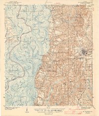
 1953 Hurricane1954 Print · USGSThe Alabama delta and its bluff-side settlements are captured here in the early 1950s, showing a landscape defined by its waterways and railroads. Genealogists and historians can locate CIVIL WAR TRENCHES, the historic Blakeley Sch, and numerous family burial grounds like Wilkins Cem.6 unique versions available
 - 1957 Map of Pensacola, 1967 Print
 1957 Pensacola1967 Print · USGSThe Florida Panhandle and Alabama coast are seen here at the height of the Cold War, showcasing a unique mix of military aviation and emerging beach tourism. Genealogists and local historians can trace legacy sites like Old Corry Field, the lumber town of Bagdad, and the coastal reaches of Santa Rosa Island.3 unique versions available
 - 1959 Map of Pensacola
 1959 Pensacola1959 Print · USGSThe Florida Panhandle and Alabama coast come alive in this late fifties survey of military aviation and maritime life. Genealogists can trace family roots in Bagdad, Loxley, and Milton while mapping the rails of the Louisville and Nashville.
 - 1960 Map of Pensacola
 1960 Pensacola1960 Print · USGSThe Florida Panhandle and Alabama's eastern shore are shown during a period of rapid military and coastal growth. Genealogists and historians can trace the mid-century footprints of Warrington, the Pensacola NAS (Chevalier), and the Blackwater River timber lands.
 - 1981 Map of Bay Minette
 1981 Bay Minette1981 Print · USGSThe Alabama-Florida borderlands come to life in the early 1980s as the river delta meets the growing coastal communities. Researchers can trace the Louisville and Nashville rail lines or locate historical points like Twenty-two Mile Bluff and the Blackwater River State Forest.2 unique versions available
 - 1997 Map of Hurricane, 2000 Print
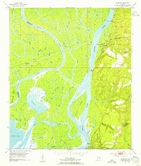
 1997 Hurricane2000 Print · USGSThe Mobile-Tensaw Delta is captured here as the millennium approached, showing a complex waterscape of bayous and historic landings. Researchers can trace the Civil War Trenches near Magnolia Ch or locate old sites like Sizemore Landing and Blakely Sch.
 - 2011 Map of Hurricane, 2011 Print
 2011 Hurricane2011 Print · USGSCovers Hurricane, including Mobile, Creola, and other nearby areas
 - 2014 Map of Hurricane, 2014 Print
 2014 Hurricane2014 Print · USGSCovers Hurricane, including Mobile, Creola, and other nearby areas
 - 2018 Map of Hurricane, 2018 Print
 2018 Hurricane2018 Print · USGSCovers Hurricane, including Mobile, Creola, and other nearby areas
 - 2020 Map of Hurricane, 2020 Print
 2020 Hurricane2020 Print · USGSCovers Hurricane, including Mobile, Creola, and other nearby areas
 - 2024 Map of Hurricane, 2024 Print
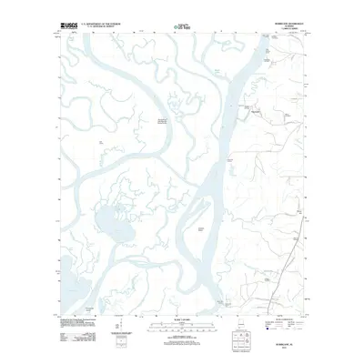
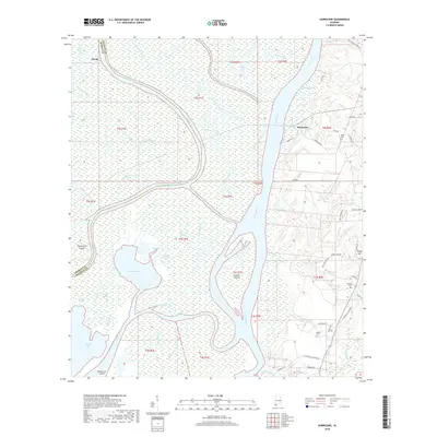
 2024 Hurricane2024 Print · USGSThe Mobile and Tensaw River delta in the 2020s is a complex maze of bayous, islands, and river channels along the Mobile-Baldwin county line. Genealogists and researchers can locate family landmarks like Miller Cem, Byrne Cem, and the Cook Memorial Presbyterian Chapel Cem on the higher ground.
End of results
Showing maps 1-15 of 15
Top cities near Hurricane
- Mobile historical maps
- Daphne historical maps
- Prichard historical maps
- Saraland historical maps
- Spanish Fort historical maps
- Bay Minette historical maps
See more
Frequently asked questions
- What are the different types of historical maps available for Hurricane?
- What is the oldest map of Hurricane?
- Where can I purchase historical maps of Hurricane for my home or office?
- Where can I download high-res historical maps of Hurricane?
- Are there historical topographic maps available for Hurricane?
- Is there historical aerial imagery available for Hurricane?
- Where are historical maps of Hurricane sourced from?