Old Maps of Blount Springs, Alabama for Genealogy
Trace your family roots with 11 historic maps of Blount Springs. These high-res maps reveal old neighborhoods, homesites, landmarks, and streets — helping you uncover where your ancestors lived and how the area evolved over time.
- Explore historic neighborhoods: Identify where your relatives may have lived in the 1800s or 1900s.
- Compare maps over time: Trace the changes in streets, buildings, and landmarks for multi-generational research.
- Perfect for genealogy & ancestry research: Used by family historians and researchers to map out lineage and migration.
These maps are an incredible resource for exploring your personal connection to Blount Springs's past.
Blount Springs, AL maps
(11)- 1889 Map of Birmingham
 1889 Birmingham1889 Print · USGSCovers Blount Springs, including Birmingham, Vestavia Hills, and other nearby areas
 - 1892 Map of Birmingham
 1892 Birmingham1892 Print · USGSCovers Blount Springs, including Birmingham, Vestavia Hills, and other nearby areas
 - 1895 Map of Birmingham
 1895 Birmingham1895 Print · USGSCovers Blount Springs, including Birmingham, Vestavia Hills, and other nearby areas2 unique versions available
 - 1907 Map of Birmingham
 1907 Birmingham1907 Print · USGSCovers Blount Springs, including Birmingham, Vestavia Hills, and other nearby areas5 unique versions available
 - 1951 Map of Blount Springs, 1952 Print
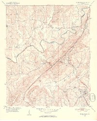 1951 Blount Springs1952 Print · USGSCovers Blount Springs, including Hayden, Garden City, and other nearby areas5 unique versions available
 - 1953 Map of Birmingham, 1964 Print
 1953 Birmingham1964 Print · USGSCovers Blount Springs, including Birmingham, Tuscaloosa, and other nearby areas4 unique versions available
 - 1956 Map of Birmingham
 1956 Birmingham1956 Print · USGSCovers Blount Springs, including Birmingham, Tuscaloosa, and other nearby areas
 - 1957 Map of Birmingham
 1957 Birmingham1957 Print · USGSCovers Blount Springs, including Birmingham, Tuscaloosa, and other nearby areas
 - 1975 Map of Blount Springs, 1977 Print
 1975 Blount Springs1977 Print · USGSCovers Blount Springs, including Hayden, Garden City, and other nearby areas
 - 1984 Map of Birmingham North, 1985 Print
 1984 Birmingham North1985 Print · USGSCovers Blount Springs, including Birmingham, Vestavia Hills, and other nearby areas2 unique versions available
 - 2024 Map of Blount Springs, 2024 Print
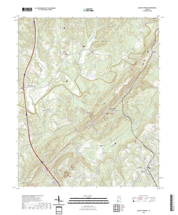 2024 Blount Springs2024 Print · USGSCovers Blount Springs, including Hayden, Garden City, and other nearby areas
End of results
Showing maps 1-11 of 11
Top cities near Blount Springs
- Trussville historical maps
- Cullman historical maps
- Gardendale historical maps
- Clay historical maps
- Pinson historical maps
- Oneonta historical maps
See more
Frequently asked questions
- What are the different types of historical maps available for Blount Springs?
- What is the oldest map of Blount Springs?
- Where can I purchase historical maps of Blount Springs for my home or office?
- Where can I download high-res historical maps of Blount Springs?
- Are there historical topographic maps available for Blount Springs?
- Is there historical aerial imagery available for Blount Springs?
- Where are historical maps of Blount Springs sourced from?