1970s Maps of Thorsby, Alabama
Explore 2 historic maps of Thorsby from the 1970s. These maps offer a rare glimpse into what life looked like during the 1970s — showing old roads, neighborhoods, homes, and landmarks that have changed or disappeared over time.
Whether you're researching your family's past, planning a metal detecting trip, or studying how Thorsby's landscape evolved across the 1970s, these high-resolution maps are a powerful tool for exploring the history of this region.
- Focus on a specific era: All maps on this page are from the 1970s, giving you a focused view of this time period.
- See what’s changed: Compare century-old streets, trails, and buildings to today's modern landscape using overlays and satellite layers.
- Research with precision: Use these maps for genealogy, historical research, land use analysis, or educational projects.
- View, download, or print: Maps are fully viewable online in high resolution, and can be downloaded or printed for your own records.
Start exploring Thorsby's history through authentic maps from the 1970s. This is your window into the past.
Thorsby, AL maps
(2)- 1971 Map of Jemison West, 1974 Print
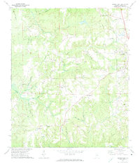 1971 Jemison West1974 Print · USGSChilton County's rural character is on full display in the early seventies as small crossroads communities thrive alongside the railroad. Genealogists and historians can trace family roots at Old Mars Hill Cem and local landmarks like Poseys Crossroads or Pates Chapel.2 unique versions available
 - 1971 Map of Jemison East, 1974 Print
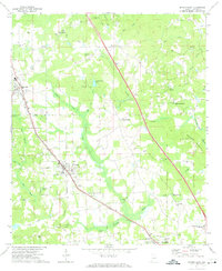 1971 Jemison East1974 Print · USGSChilton County in the early seventies is defined by the busy Louisville and Nashville rail corridor and rural crossroads. Local historians can trace family locations through numerous landmarks like Collins Chapel, Thorsby, and the Cedar Grove Ch Cem.2 unique versions available
End of results
Showing maps 1-2 of 2
Top cities near Thorsby
- Calera historical maps
- Clanton historical maps
- Montevallo historical maps
- Jemison historical maps
- Shelby historical maps
- Maplesville historical maps
See more
Frequently asked questions
- What are the different types of historical maps available for Thorsby?
- What is the oldest map of Thorsby?
- Where can I purchase historical maps of Thorsby for my home or office?
- Where can I download high-res historical maps of Thorsby?
- Are there historical topographic maps available for Thorsby?
- Is there historical aerial imagery available for Thorsby?
- Where are historical maps of Thorsby sourced from?