1960s Maps of Wilkinstown, Alabama
Explore 2 historic maps of Wilkinstown from the 1960s. These maps offer a rare glimpse into what life looked like during the 1960s — showing old roads, neighborhoods, homes, and landmarks that have changed or disappeared over time.
Whether you're researching your family's past, planning a metal detecting trip, or studying how Wilkinstown's landscape evolved across the 1960s, these high-resolution maps are a powerful tool for exploring the history of this region.
- Focus on a specific era: All maps on this page are from the 1960s, giving you a focused view of this time period.
- See what’s changed: Compare century-old streets, trails, and buildings to today's modern landscape using overlays and satellite layers.
- Research with precision: Use these maps for genealogy, historical research, land use analysis, or educational projects.
- View, download, or print: Maps are fully viewable online in high resolution, and can be downloaded or printed for your own records.
Start exploring Wilkinstown's history through authentic maps from the 1960s. This is your window into the past.
Wilkinstown, AL maps
(2)- 1960 Map of Victoria, 1963 Print
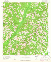 1960 Victoria1963 Print · USGSDeep in the Alabama wiregrass region during the early sixties, this area shows a landscape defined by the winding Whitewater Creek and the Pea River. Researchers can trace rural life through landmarks like Lowry Mill, Clowers Crossroads, and Bethlehem Ch.2 unique versions available
 - 1962 Map of Victoria
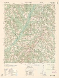 1962 Victoria1962 Print · USGSThe borderlands of Coffee and Pike County come alive in the early sixties, showing a landscape defined by small farms and country churches. Researchers can locate the Victoria School, the site of Lowry Mill, and local landmarks like Clowers Crossroads.
End of results
Showing maps 1-2 of 2
Top cities near Wilkinstown
- Enterprise historical maps
- Troy historical maps
- Elba historical maps
- Brundidge historical maps
- New Brockton historical maps
- Goshen historical maps
See more
Frequently asked questions
- What are the different types of historical maps available for Wilkinstown?
- What is the oldest map of Wilkinstown?
- Where can I purchase historical maps of Wilkinstown for my home or office?
- Where can I download high-res historical maps of Wilkinstown?
- Are there historical topographic maps available for Wilkinstown?
- Is there historical aerial imagery available for Wilkinstown?
- Where are historical maps of Wilkinstown sourced from?