1900s (20th Century) Maps of Lime Kiln, Alabama
Explore 9 historic maps of Lime Kiln from the 1900s (20th Century). These maps offer a rare glimpse into what life looked like during the 1900s — showing old roads, neighborhoods, homes, and landmarks that have changed or disappeared over time.
Whether you're researching your family's past, planning a metal detecting trip, or studying how Lime Kiln's landscape evolved across the 1900s, these high-resolution maps are a powerful tool for exploring the history of this region.
- Focus on a specific era: All maps on this page are from the 1900s, giving you a focused view of this time period.
- See what’s changed: Compare century-old streets, trails, and buildings to today's modern landscape using overlays and satellite layers.
- Research with precision: Use these maps for genealogy, historical research, land use analysis, or educational projects.
- View, download, or print: Maps are fully viewable online in high resolution, and can be downloaded or printed for your own records.
Start exploring Lime Kiln's history through authentic maps from the 1900s. This is your window into the past.
Lime Kiln, AL maps
(9)- 1911 Map of Iuka
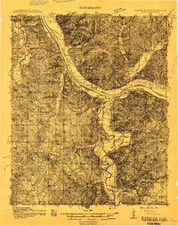 1911 Iuka1911 Print · USGSThe tri-state border region of Mississippi, Alabama, and Tennessee is captured here at the peak of the river-landing era. Genealogists can trace family connections through numerous river access points like Shellbank Landing and rural landmarks such as Salem Church and Jackson Ridge School.2 unique versions available
 - 1914 Map of Iuka
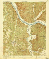 1914 Iuka1914 Print · USGSThe Tennessee River valley at the Mississippi and Alabama border was a busy network of landings and rail junctions in the early twentieth century. Researchers can trace riverfront life at Eastport Landing or locate rural family landmarks like Salem Church and Guthrie School.4 unique versions available
 - 1936 Map of Margerum
 1936 Margerum1936 Print · USGSThe Alabama-Mississippi borderland is captured during a time of immense change as the Tennessee Valley Authority prepares for the Pickwick Landing Reservoir. Local historians can trace family roots through sites like Carytown Ch, Crenshaw Cem, and the settlement of Margerum.
 - 1953 Map of Margerum, 1958 Print
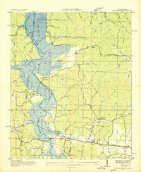
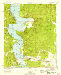 1953 Margerum1958 Print · USGSThe Colbert County shoreline and the community of Margerum appear here in the early fifties as Pickwick Lake reshapes the valley. Trace industrial sites like the Alabama Asphaltic Limestone Company and rural landmarks such as Douthit Ch and a covered bridge.4 unique versions available
 - 1956 Map of Tupelo, 1967 Print
 1956 Tupelo1967 Print · USGSNortheast Mississippi and parts of Tennessee and Alabama are shown here during the mid-fifties, a time of major reservoir construction and forestry management. Researchers can trace the St Louis-San Francisco RR through Tupelo or locate historic sites like Tishomingo State Park and the University.2 unique versions available
 - 1958 Map of Tupelo
 1958 Tupelo1958 Print · USGSNortheast Mississippi and neighboring Alabama and Tennessee appear here during the late fifties as a region defined by new reservoirs and historic rail lines. Genealogists can trace family locations near Sardis Lake, Woodall Mountain, and the St Louis-San Francisco Ry.
 - 1984 Map of Corinth
 1984 Corinth1984 Print · USGSNortheast Mississippi and its borders with Alabama and Tennessee are captured here in the mid-1980s, showcasing a landscape of rail-connected towns and ridge-top settlements. Researchers can trace the path of the Natchez Trace Parkway or locate family-named landmarks near Biggersville, Kossuth, and the historic Tennessee Divide.
 - 1984 Map of Tupelo
 1984 Tupelo1984 Print · USGSNorth Mississippi in the 1980s is defined by its massive river basin reservoirs and the growing regional hubs of Tupelo and Oxford. Researchers can trace the legacy of the Pontotoc Ridge, find the University of Mississippi, and map early Interstate corridors near Sardis Lake.3 unique versions available
 - 1994 Map of Corinth
 1994 Corinth1994 Print · USGSNortheast Mississippi and the Tennessee borderlands are captured in the mid-1990s as the region's modern industrial and recreational landscape took shape. Genealogists and historians can trace rail-to-river connections through Corinth, the old courthouse at Jacinto, and the route of the Natchez Trace Parkway.
End of results
Showing maps 1-9 of 9
Top cities near Lime Kiln
- Iuka historical maps
- Cherokee historical maps
- Tishomingo historical maps
- Waterloo historical maps
- Paden historical maps
Frequently asked questions
- What are the different types of historical maps available for Lime Kiln?
- What is the oldest map of Lime Kiln?
- Where can I purchase historical maps of Lime Kiln for my home or office?
- Where can I download high-res historical maps of Lime Kiln?
- Are there historical topographic maps available for Lime Kiln?
- Is there historical aerial imagery available for Lime Kiln?
- Where are historical maps of Lime Kiln sourced from?