1930s Maps of Muscle Shoals, Alabama
Explore 4 historic maps of Muscle Shoals from the 1930s. These maps offer a rare glimpse into what life looked like during the 1930s — showing old roads, neighborhoods, homes, and landmarks that have changed or disappeared over time.
Whether you're researching your family's past, planning a metal detecting trip, or studying how Muscle Shoals's landscape evolved across the 1930s, these high-resolution maps are a powerful tool for exploring the history of this region.
- Focus on a specific era: All maps on this page are from the 1930s, giving you a focused view of this time period.
- See what’s changed: Compare century-old streets, trails, and buildings to today's modern landscape using overlays and satellite layers.
- Research with precision: Use these maps for genealogy, historical research, land use analysis, or educational projects.
- View, download, or print: Maps are fully viewable online in high resolution, and can be downloaded or printed for your own records.
Start exploring Muscle Shoals's history through authentic maps from the 1930s. This is your window into the past.
Muscle Shoals, AL maps
(4)- 1936 Map of Florence
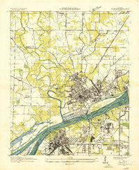 1936 Florence1936 Print · USGSThe Shoals area enters the TVA era as the river prepares for the new reservoir. Genealogists and historians can trace Oakwood Cem, the Coffee Rosenwald Sch, and early federal housing at Wilson Dam Village No 3.
 - 1936 Map of Leighton
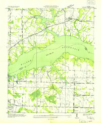
 1936 Leighton1936 Print · USGSLeighton and the surrounding Colbert County countryside are shown here in the mid-1930s as the Tennessee Valley Authority began transforming the region. Researchers can locate family-named sites like Bickley Place, community centers such as Valley Grove Ch, and the old Lagrange Cem.
 - 1936 Map of Tuscumbia
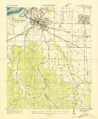 1936 Tuscumbia1936 Print · USGSNorthwest Alabama undergoes a massive transition in the mid-thirties as federal projects reshape the Tennessee River. Trace old family roots at Underwood Cem, the early rail network through Noralia Junction, or the vanished industrial layout of Nitrate Plant No 1.
 - 1936 Map of Killen
 1936 Killen1936 Print · USGSThe Tennessee River valley transformed in the mid-thirties as hydroelectric power and industrial villages reshaped the Alabama landscape. Genealogists can locate family landmarks like Mt Pleasant Cemetery or early educational sites such as Price School and Harkins Creek School.
End of results
Showing maps 1-4 of 4
Top cities near Muscle Shoals
- Florence historical maps
- Russellville historical maps
- Sheffield historical maps
- Tuscumbia historical maps
- Underwood-Petersville historical maps
- Town Creek historical maps
See more
Top neighborhoods of Muscle Shoals
- Jackson Heights historical maps
- Cave Spring historical maps
- East Haven historical maps
- Highland Park historical maps
- Houston Corner historical maps
- Lakeview historical maps
See more
Frequently asked questions
- What are the different types of historical maps available for Muscle Shoals?
- What is the oldest map of Muscle Shoals?
- Where can I purchase historical maps of Muscle Shoals for my home or office?
- Where can I download high-res historical maps of Muscle Shoals?
- Are there historical topographic maps available for Muscle Shoals?
- Is there historical aerial imagery available for Muscle Shoals?
- Where are historical maps of Muscle Shoals sourced from?