1900s (20th Century) Maps of Andalusia, Alabama
Explore 5 historic maps of Andalusia from the 1900s (20th Century). These maps offer a rare glimpse into what life looked like during the 1900s — showing old roads, neighborhoods, homes, and landmarks that have changed or disappeared over time.
Whether you're researching your family's past, planning a metal detecting trip, or studying how Andalusia's landscape evolved across the 1900s, these high-resolution maps are a powerful tool for exploring the history of this region.
- Focus on a specific era: All maps on this page are from the 1900s, giving you a focused view of this time period.
- See what’s changed: Compare century-old streets, trails, and buildings to today's modern landscape using overlays and satellite layers.
- Research with precision: Use these maps for genealogy, historical research, land use analysis, or educational projects.
- View, download, or print: Maps are fully viewable online in high resolution, and can be downloaded or printed for your own records.
Start exploring Andalusia's history through authentic maps from the 1900s. This is your window into the past.
Andalusia, AL maps
(5)- 1953 Map of Andalusia, 1965 Print
 1953 Andalusia1965 Print · USGSSouth Alabama in the mid-twentieth century remains a land of pine forests and river-fed settlements. You can trace the vital rail corridors of the Louisville & Nashville and locate regional centers such as Andalusia, Brewton, and Monroeville.3 unique versions available
 - 1957 Map of Andalusia
 1957 Andalusia1957 Print · USGSSouthern Alabama in the mid-1950s was a landscape defined by timbered stretches and the rhythmic flow of the Alabama River. Researchers can trace the legacy of the rail era through the Central of Georgia tracks and the storied river bluffs at Choctaw Bluff.
 - 1971 Map of River Falls, 1973 Print
 1971 River Falls1973 Print · USGSThe Conecuh River valley in the early seventies shows the rural landscape of Covington County as it balanced industry and tradition. Genealogists can trace family roots through numerous sites like Presley Chapel, Cedar Grove Ch, and Bethlehem Cem.2 unique versions available
 - 1971 Map of Andalusia, 1973 Print
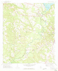
 1971 Andalusia1973 Print · USGSCovington County in the early seventies centers on the bustling rail junction and academic institutions of Andalusia. Local historians can trace the paths of the Central of Georgia railroad or locate family sites at Bethany Ch, Magnolia Cem, and the Montezuma Academy.2 unique versions available
 - 1986 Map of Andalusia
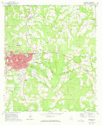
 1986 Andalusia1986 Print · USGSCovington County and the Wiregrass region are shown here in the mid-1980s, centered on the growing hubs of Andalusia and Opp. Genealogists and local historians can trace legacy sites like the Old Pioneer Cem, Straughn Sch, and the rail lines of the Louisville and Nashville RR.2 unique versions available
End of results
Showing maps 1-5 of 5
Top cities near Andalusia
- Opp historical maps
- Babbie historical maps
- River Falls historical maps
- Red Level historical maps
- Carolina historical maps
- Dozier historical maps
See more
Frequently asked questions
- What are the different types of historical maps available for Andalusia?
- What is the oldest map of Andalusia?
- Where can I purchase historical maps of Andalusia for my home or office?
- Where can I download high-res historical maps of Andalusia?
- Are there historical topographic maps available for Andalusia?
- Is there historical aerial imagery available for Andalusia?
- Where are historical maps of Andalusia sourced from?