1970s Maps of Rome, Alabama
Explore 1 historic maps of Rome from the 1970s. These maps offer a rare glimpse into what life looked like during the 1970s — showing old roads, neighborhoods, homes, and landmarks that have changed or disappeared over time.
Whether you're researching your family's past, planning a metal detecting trip, or studying how Rome's landscape evolved across the 1970s, these high-resolution maps are a powerful tool for exploring the history of this region.
- Focus on a specific era: All maps on this page are from the 1970s, giving you a focused view of this time period.
- See what’s changed: Compare century-old streets, trails, and buildings to today's modern landscape using overlays and satellite layers.
- Research with precision: Use these maps for genealogy, historical research, land use analysis, or educational projects.
- View, download, or print: Maps are fully viewable online in high resolution, and can be downloaded or printed for your own records.
Start exploring Rome's history through authentic maps from the 1970s. This is your window into the past.
Rome, AL maps
(1)- 1971 Map of Dixie, 1972 Print
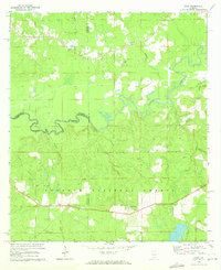 1971 Dixie1972 Print · USGSIn the early seventies, the borderlands of Escambia and Covington counties remained a world of deep timber and quiet settlements. Genealogists can locate family landmarks like Mason Cem and Welfare Ch, or trace the path of the Old RR Grade through the Conecuh National Forest.3 unique versions available
End of results
Showing maps 1-1 of 1
Top cities near Rome
- Andalusia historical maps
- Laurel Hill historical maps
- River Falls historical maps
- Carolina historical maps
- Heath historical maps
- Libertyville historical maps
Frequently asked questions
- What are the different types of historical maps available for Rome?
- What is the oldest map of Rome?
- Where can I purchase historical maps of Rome for my home or office?
- Where can I download high-res historical maps of Rome?
- Are there historical topographic maps available for Rome?
- Is there historical aerial imagery available for Rome?
- Where are historical maps of Rome sourced from?