1940s Maps of Grove Oak, Alabama
Explore 2 historic maps of Grove Oak from the 1940s. These maps offer a rare glimpse into what life looked like during the 1940s — showing old roads, neighborhoods, homes, and landmarks that have changed or disappeared over time.
Whether you're researching your family's past, planning a metal detecting trip, or studying how Grove Oak's landscape evolved across the 1940s, these high-resolution maps are a powerful tool for exploring the history of this region.
- Focus on a specific era: All maps on this page are from the 1940s, giving you a focused view of this time period.
- See what’s changed: Compare century-old streets, trails, and buildings to today's modern landscape using overlays and satellite layers.
- Research with precision: Use these maps for genealogy, historical research, land use analysis, or educational projects.
- View, download, or print: Maps are fully viewable online in high resolution, and can be downloaded or printed for your own records.
Start exploring Grove Oak's history through authentic maps from the 1940s. This is your window into the past.
Grove Oak, AL maps
(2)- 1946 Map of Grove Oak, 1972 Print
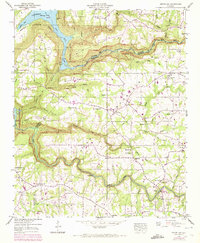 1946 Grove Oak1972 Print · USGSThe plateaus of DeKalb and Marshall Counties are captured here mid-century, just as rural land use began to shift. Genealogists can locate family landmarks like Bethlehem Sch and several country meeting houses, including Salem Ch and Mt Nebo Ch.2 unique versions available
 - 1949 Map of Grove Oak
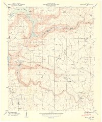 1949 Grove Oak1949 Print · USGSDeKalb and Marshall counties are shown here just after the war, where the plateau of Sand Mountain meets the backwaters of the Tennessee River. Researchers can trace rural life through dozens of landmarks like Poplar Springs Ch, Bethlehem Sch, and the Elrod Bridge.2 unique versions available
End of results
Showing maps 1-2 of 2
Top cities near Grove Oak
- Albertville historical maps
- Scottsboro historical maps
- Boaz historical maps
- Guntersville historical maps
- Rainsville historical maps
- Collinsville historical maps
See more
Frequently asked questions
- What are the different types of historical maps available for Grove Oak?
- What is the oldest map of Grove Oak?
- Where can I purchase historical maps of Grove Oak for my home or office?
- Where can I download high-res historical maps of Grove Oak?
- Are there historical topographic maps available for Grove Oak?
- Is there historical aerial imagery available for Grove Oak?
- Where are historical maps of Grove Oak sourced from?