1930s Maps of Henagar, Alabama
Explore 4 historic maps of Henagar from the 1930s. These maps offer a rare glimpse into what life looked like during the 1930s — showing old roads, neighborhoods, homes, and landmarks that have changed or disappeared over time.
Whether you're researching your family's past, planning a metal detecting trip, or studying how Henagar's landscape evolved across the 1930s, these high-resolution maps are a powerful tool for exploring the history of this region.
- Focus on a specific era: All maps on this page are from the 1930s, giving you a focused view of this time period.
- See what’s changed: Compare century-old streets, trails, and buildings to today's modern landscape using overlays and satellite layers.
- Research with precision: Use these maps for genealogy, historical research, land use analysis, or educational projects.
- View, download, or print: Maps are fully viewable online in high resolution, and can be downloaded or printed for your own records.
Start exploring Henagar's history through authentic maps from the 1930s. This is your window into the past.
Henagar, AL maps
(4)- 1936 Map of Ider
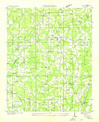 1936 Ider1936 Print · USGSThe plateau of De Kalb and Jackson counties is captured here in the mid-1930s as a network of crossroads and family farms. Local historians can trace family roots through sites like Yorks Mill, Pilgrims Home Ch, and the Fuller Cem.
 - 1936 Map of Dugout Valley
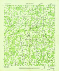
 1936 Dugout Valley1936 Print · USGSDeKalb County mountain life in the mid-1930s is captured here, showing the scattered farmsteads and schools along SAND MOUNTAIN. Genealogists can locate family landmarks such as Hawkins Chapel Sch, Blackburns Store, and Mt Parron Ch tucked between the ridges.
 - 1936 Map of Sylvania
 1936 Sylvania1936 Print · USGSSand Mountain's rural plateau comes to life in the mid-1930s, showing a landscape of family farms and community centers. Genealogists can trace family footprints at Bowman Crossroads, Mahan Sch, or the Dean Chapel Cem.
 - 1936 Map of Henagar
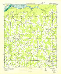 1936 Henagar1936 Print · USGSDeKalb and Jackson counties were undergoing significant change in the mid-1930s as the Tennessee Valley Authority developed the region. Researchers can locate early educational and religious sites including Chalybeate Springs Sch, Friendship Ch, and the settlement of Pisgah.
End of results
Showing maps 1-4 of 4
Top cities near Henagar
- Scottsboro historical maps
- Fort Payne historical maps
- Rainsville historical maps
- Trenton historical maps
- Stevenson historical maps
- Sylvania historical maps
See more
Top neighborhoods of Henagar
- Brooks Crossroads historical maps
- Biddle Crossroads historical maps
- Pea Ridge Crossroads historical maps
- Elliott Crossroads historical maps
Frequently asked questions
- What are the different types of historical maps available for Henagar?
- What is the oldest map of Henagar?
- Where can I purchase historical maps of Henagar for my home or office?
- Where can I download high-res historical maps of Henagar?
- Are there historical topographic maps available for Henagar?
- Is there historical aerial imagery available for Henagar?
- Where are historical maps of Henagar sourced from?