1940s Maps of Pea Ridge Crossroads, Henagar
Explore 2 historic maps of Pea Ridge Crossroads from the 1940s. These maps offer a rare glimpse into what life looked like during the 1940s — showing old roads, neighborhoods, homes, and landmarks that have changed or disappeared over time.
Whether you're researching your family's past, planning a metal detecting trip, or studying how Pea Ridge Crossroads's landscape evolved across the 1940s, these high-resolution maps are a powerful tool for exploring the history of this region.
- Focus on a specific era: All maps on this page are from the 1940s, giving you a focused view of this time period.
- See what’s changed: Compare century-old streets, trails, and buildings to today's modern landscape using overlays and satellite layers.
- Research with precision: Use these maps for genealogy, historical research, land use analysis, or educational projects.
- View, download, or print: Maps are fully viewable online in high resolution, and can be downloaded or printed for your own records.
Start exploring Pea Ridge Crossroads's history through authentic maps from the 1940s. This is your window into the past.
Pea Ridge Crossroads, Henagar maps
(2)- 1946 Map of Ider, 1956 Print
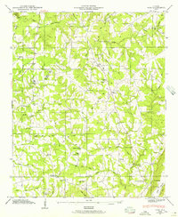 1946 Ider1956 Print · USGSDeKalb County upland life in the mid-1940s centers on the family-named crossroads of Sand Mountain. Researchers can trace rural landmarks from Yorks Mill and Freehill Sch to numerous country churches like New Bethel Ch No 2.2 unique versions available
 - 1947 Map of Ider
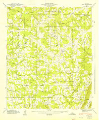 1947 Ider1947 Print · USGSDeKalb and Jackson County communities are captured here in the late 1940s, highlighting the intricate network of Sand Mountain crossroads. Local historians can locate Yorks Mill, the Fuller Cem, and several named intersections like Skaggs Corner.2 unique versions available
End of results
Showing maps 1-2 of 2
Top cities near Pea Ridge Crossroads
- Fort Payne historical maps
- Rainsville historical maps
- Henagar historical maps
- Trenton historical maps
- Stevenson historical maps
- Sylvania historical maps
See more
Frequently asked questions
- What are the different types of historical maps available for Pea Ridge Crossroads?
- What is the oldest map of Pea Ridge Crossroads?
- Where can I purchase historical maps of Pea Ridge Crossroads for my home or office?
- Where can I download high-res historical maps of Pea Ridge Crossroads?
- Are there historical topographic maps available for Pea Ridge Crossroads?
- Is there historical aerial imagery available for Pea Ridge Crossroads?
- Where are historical maps of Pea Ridge Crossroads sourced from?