1940s Maps of Rainsville, Alabama
Explore 6 historic maps of Rainsville from the 1940s. These maps offer a rare glimpse into what life looked like during the 1940s — showing old roads, neighborhoods, homes, and landmarks that have changed or disappeared over time.
Whether you're researching your family's past, planning a metal detecting trip, or studying how Rainsville's landscape evolved across the 1940s, these high-resolution maps are a powerful tool for exploring the history of this region.
- Focus on a specific era: All maps on this page are from the 1940s, giving you a focused view of this time period.
- See what’s changed: Compare century-old streets, trails, and buildings to today's modern landscape using overlays and satellite layers.
- Research with precision: Use these maps for genealogy, historical research, land use analysis, or educational projects.
- View, download, or print: Maps are fully viewable online in high resolution, and can be downloaded or printed for your own records.
Start exploring Rainsville's history through authentic maps from the 1940s. This is your window into the past.
Rainsville, AL maps
(6)- 1946 Map of Chavies, 1964 Print
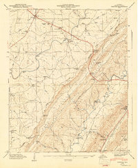
 1946 Chavies1964 Print · USGSDeKalb County’s plateau and valley communities are captured in detail just after the war, showing the rural networks of Rainsville and Chavies. Researchers can locate old schools and river crossings like Log Cabin School, Suttell Ford, and the Mt Herman Cemetery.3 unique versions available
 - 1946 Map of Fyffe, 1972 Print
 1946 Fyffe1972 Print · USGSDeKalb County enters a period of post-war growth on Sand Mountain as rural settlements like Fyffe and Ten Broeck began to expand. Genealogists and historians can trace family land near Gibson Crossroads, Warren Cem, and several local congregations including Beulah Ch.2 unique versions available
 - 1947 Map of Chavies
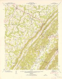
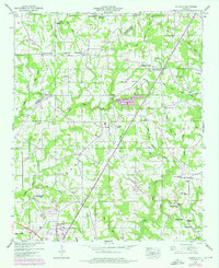
 1947 Chavies1947 Print · USGSDeKalb County ridge-and-valley country is captured here in the late 1940s, showing the rural uplands of SAND MOUNTAIN and the BIG WILLS VALLEY below. Genealogists and historians can trace local landmarks like Plainview Sch, Hughes Mill, and old river crossings at Franklin Ford.
 - 1947 Map of Dutton, 1972 Print
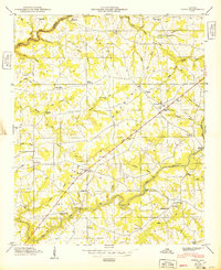
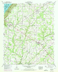 1947 Dutton1972 Print · USGSSand Mountain settlements and the Guntersville Lake shoreline appear in this mid-century survey as the Tennessee Valley transformed. Trace family roots at Chaney Chapel Cem or locate old community hubs like Gossett Gap and Hancock Crossroads.2 unique versions available
 - 1947 Map of Sylvania, 1976 Print
 1947 Sylvania1976 Print · USGSDeKalb County’s plateau communities are shown in detail during the mid-twentieth century as Rainsville and Sylvania began to expand along the highway. Researchers can trace family roots through numerous sites like Double Spring Church, Mahan Cem, and the old Wilkes Store.3 unique versions available
 - 1949 Map of Fyffe
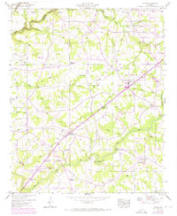
 1949 Fyffe1949 Print · USGSDe Kalb County is shown in the late 1940s as a high-plateau farming community centered on the crossroads of Fyffe. Researchers can trace early family sites at Warren Cem Graveyard, find the old Ten Broeck landmark, or locate numerous rural pulpits like Old Corinth Ch.2 unique versions available
End of results
Showing maps 1-6 of 6
Top cities near Rainsville
- Scottsboro historical maps
- Fort Payne historical maps
- Henagar historical maps
- Collinsville historical maps
- Crossville historical maps
- Sylvania historical maps
See more
Top neighborhoods of Rainsville
- Pope historical maps
- Chavies historical maps
- Lands Crossroads historical maps
- Plainview historical maps
Frequently asked questions
- What are the different types of historical maps available for Rainsville?
- What is the oldest map of Rainsville?
- Where can I purchase historical maps of Rainsville for my home or office?
- Where can I download high-res historical maps of Rainsville?
- Are there historical topographic maps available for Rainsville?
- Is there historical aerial imagery available for Rainsville?
- Where are historical maps of Rainsville sourced from?