Old Maps of Elmore County, Alabama
Explore 157 old maps of Elmore County, spanning from 1901 to today. These high-resolution historic maps reveal how streets, neighborhoods, landmarks, and natural features evolved over time — perfect for genealogy, metal detecting, research, and local history exploration.
What you can do with these maps:
- See how Elmore County changed over time: Compare historical maps to modern-day views to trace roads, homesites, rail lines & more.
- View detailed metadata: Each map includes creators, publishers, year, scale, and archive source.
- Overlay maps with satellite & LiDAR: Visualize the past alongside modern tools to explore terrain & human change.
- Trusted historical sources: Maps sourced from the USGS, Library of Congress, and other archives.
- Access maps your way: View online, download high-res files, or order prints for personal or research use.
Start exploring old maps of Elmore County to uncover forgotten places, hidden landmarks, and the deep history beneath your feet.
Elmore County, AL maps
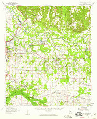
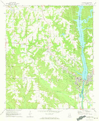
(157)- 1901 Map of Wetumpka
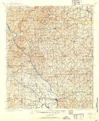
 1901 Wetumpka1901 Print · USGSCentral Alabama at the dawn of the twentieth century was a landscape of river ferries and emerging rail lines. Genealogists and local historians can trace family-named river crossings like Knights Ferry and Nobles Ferry or early community centers such as Nixburg and Eclectic.
 - 1901 Map of Wetumpka
 1901 Wetumpka1901 Print · USGSCentral Alabama at the turn of the century centers on the river junctions and early rail lines of Elmore and Coosa Counties. Trace the historical routes of the Louisville & Nashville RR and find long-forgotten sites like Sykes Mills and Liberty Church.
 - 1903 Map of Wetumpka
 1903 Wetumpka1903 Print · USGSCentral Alabama at the turn of the century remains a landscape of river ferries and emerging rail lines along the Coosa River. Genealogists and researchers can trace the early locations of Sykes Mills, Liberty Church, and river crossings like Nobles Ferry.3 unique versions available
 - 1906 Map of Dadeville
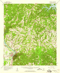
 1906 Dadeville1906 Print · USGSThe Tallapoosa River valley is shown at the turn of the century, defined by its numerous river ferries and a burgeoning rail network. Genealogists can trace family roots through rural landmarks like Rocky Ridge Church, Mc Ritchie Mill, and the many river crossings including McCarty Ferry.3 unique versions available
 - 1927 Map of Montgomery
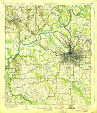
 1927 Montgomery1927 Print · USGSThe Alabama state capital and its river-bend surroundings are seen here in the late twenties during a period of growth. Researchers can trace the footprints of Maxwell Aviation Field, the Masonic Home, and rural sites like Stones Cem.
 - 1930 Map of Montgomery
 1930 Montgomery1930 Print · USGSThe Alabama state capital is seen here as a bustling rail and river crossroads in the late twenties. Trace the historic growth of the city and its surrounding rural communities through sites like Maxwell Aviation Field, Kilby Prison, and Oakwood Cemetery.4 unique versions available
 - 1953 Map of Montgomery, 1964 Print
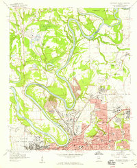
 1953 Montgomery1964 Print · USGSCentral Alabama's river-and-rail corridor is mapped here in the mid-fifties, showing the vital connections between the capital and the Black Belt. Genealogists and historians can trace rail depots and crossroads from Marion Junction to Wetumpka, alongside landmarks like Craig AFB.4 unique versions available
 - 1955 Map of Phenix City, 1964 Print
 1955 Phenix City1964 Print · USGSPost-war Alabama and Georgia meet along the Chattahoochee River as industry and military installations expand. Trace the rail lines of the Central of Georgia through towns like Opelika, Tuskegee, and Alexander City.3 unique versions available
 - 1956 Map of Montgomery
 1956 Montgomery1956 Print · USGSCentral Alabama in the mid-1950s shows a landscape defined by its great river systems and a booming military aviation presence. Genealogists and historians can trace the rail corridors of the Southern Railway and locate tactical bases like Maxwell AFB and Craig AFB.
 - 1957 Map of Phenix City
 1957 Phenix City1957 Print · USGSThe Alabama-Georgia borderlands are captured here in the mid-fifties, centered on the bustling river crossing at Phenix City and Columbus. Researchers can trace the mid-century footprint of the Fort Benning Military Reservation or locate smaller textile and railroad towns like Langdale and Camp Hill.
 - 1957 Map of Montgomery
 1957 Montgomery1957 Print · USGSCentral Alabama in the mid-fifties is defined by the winding Alabama River and a strategic network of military bases and rail lines. Trace family roots in Montgomery and Selma, or locate landmarks like Craig AFB and the State Capitol before the interstate era.
 - 1958 Map of Phenix City
 1958 Phenix City1958 Print · USGSThe Alabama-Georgia borderlands thrive during the late fifties, anchored by the river-driven industry of Columbus and Phenix City. Researchers can trace the mid-century footprints of Fort Benning, Auburn, and the textile towns of Fairfax and Lanett.
 - 1958 Map of Montgomery, 1959 Print
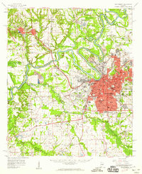 1958 Montgomery1959 Print · USGSThe state capital and its surrounding river bends are captured here during the late fifties, a period of significant military and urban growth. Researchers can trace historic institutions like Alabama State College and the extensive grounds of Maxwell Air Force Base.2 unique versions available
 - 1958 Map of Montgomery North, 1959 Print
 1958 Montgomery North1959 Print · USGSMontgomery and its northern river bends are captured here in the late fifties, showcasing a period of significant urban and military expansion. Genealogists can trace family landmarks and neighborhoods from Oakwood Cemetery to Millbrook, including rural sites like Coles Chapel and Goodship Ch.4 unique versions available
 - 1958 Map of Mount Meigs, 1959 Print
 1958 Mount Meigs1959 Print · USGSMontgomery County was a hive of rail and river activity in the late fifties as the state capital expanded eastward. Researchers can trace family-named sites and rural institutions like Pike Road, Our Lady of Fatima Sch, and the riverside Indian Mounds.2 unique versions available
 - 1959 Map of Wetumpka, 1960 Print
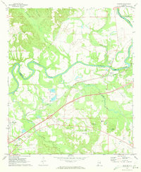
 1959 Wetumpka1960 Print · USGSWetumpka and the Coosa River valley are shown in the late fifties as the regional rail and river network supported a growing community. Genealogists can trace family landmarks across Eclectic and Seman, from Tutwiler Prison to the Old Indian Boundary.2 unique versions available
 - 1959 Map of Elmore, 1960 Print
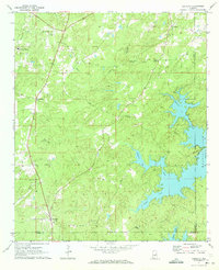
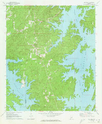
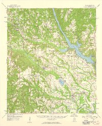 1959 Elmore1960 Print · USGSElmore County during the late fifties reveals a landscape shaped by the Coosa River and the bustling Louisville and Nashville railroad. Genealogists can trace family names at Zeigler Cem, visit the Union Rosenwald Sch, or locate the aviation footprint of the Elmore Landing Field.2 unique versions available
 - 1971 Map of Richville, 1973 Print
 1971 Richville1973 Print · USGSCoosa County in the early seventies shows a landscape of rural crossroads and creek-fed valleys. Genealogists and local historians can trace family-named sites like Murchison Cem and the small settlements of Richville and Welona.2 unique versions available
 - 1971 Map of Mitchell Dam, 1973 Print
 1971 Mitchell Dam1973 Print · USGSThe Coosa River valley is captured here in the early seventies, dominated by the waters of Mitchell and Jordan Lakes. Researchers can trace rural life through landmarks like Corinth Ch, Williams Cem, and the massive hydroelectric works at Mitchell Dam.2 unique versions available
 - 1971 Map of Tallassee, 1973 Print
 1971 Tallassee1973 Print · USGSThe Tallapoosa River corridor in the early 1970s reveals a landscape shaped by hydroelectric power and traditional rural settlements. Genealogists and local historians can trace family roots through landmarks like Rosehill Cem, Providence Ch, and the mills along Wallahatchee Creek.2 unique versions available
 - 1971 Map of Equality, 1973 Print
 1971 Equality1973 Print · USGSThe Coosa County hill country meets the rising waters of the Tallapoosa during the early 1970s. Genealogists can trace family landmarks like Nixburg Cem and Shiloh Cem or locate the site of the historic Covered Br on Oakachoy Creek.2 unique versions available
 - 1971 Map of Shorter, 1973 Print
 1971 Shorter1973 Print · USGSThe Tallapoosa River country comes alive in the early seventies, showing a landscape of small towns and gravel works. Trace local history at Tysonville, the Cubahatchee Lookout Tower, and Wolfe High Sch.2 unique versions available
 - 1971 Map of La Place, 1973 Print
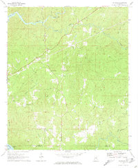
 1971 La Place1973 Print · USGSMacon County in the early seventies shows a landscape where military history and rural tradition meet along the Tallapoosa River. Researchers can locate the Tuskegee Air Force Base and numerous family churches like Bradford Chapel and Elam Ch.2 unique versions available
 - 1971 Map of Our Town, 1973 Print
 1971 Our Town1973 Print · USGSTallapoosa County and the winding shores of Martin Lake are captured here in the early seventies as recreation and local life converged. Genealogists can trace family names at Mt Zion Cem and Mask Cem or locate the rural settlement of Our Town.2 unique versions available
 - 1971 Map of Rockford SW, 1973 Print
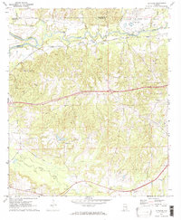
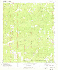 1971 Rockford SW1973 Print · USGSCoosa County in the early 1970s remains a landscape of upland farms and traditional community anchors. Researchers can trace the heritage of central Alabama through sites like Pentonville, Mt Nebo Ch, and the Lindsey Cem.2 unique versions available
Showing maps 1-25 of 157
Top cities of Elmore County
- Millbrook historical maps
- Wetumpka historical maps
- Holtville historical maps
- Emerald Mountain historical maps
- Deatsville historical maps
- Blue Ridge historical maps
See more
Frequently asked questions
- What are the different types of historical maps available for Elmore County?
- What is the oldest map of Elmore County?
- Where can I purchase historical maps of Elmore County for my home or office?
- Where can I download high-res historical maps of Elmore County?
- Are there historical topographic maps available for Elmore County?
- Is there historical aerial imagery available for Elmore County?
- Where are historical maps of Elmore County sourced from?