1970s Maps of Elmore County, Alabama
Explore 18 historic maps of Elmore County from the 1970s. These maps offer a rare glimpse into what life looked like during the 1970s — showing old roads, neighborhoods, homes, and landmarks that have changed or disappeared over time.
Whether you're researching your family's past, planning a metal detecting trip, or studying how Elmore County's landscape evolved across the 1970s, these high-resolution maps are a powerful tool for exploring the history of this region.
- Focus on a specific era: All maps on this page are from the 1970s, giving you a focused view of this time period.
- See what’s changed: Compare century-old streets, trails, and buildings to today's modern landscape using overlays and satellite layers.
- Research with precision: Use these maps for genealogy, historical research, land use analysis, or educational projects.
- View, download, or print: Maps are fully viewable online in high resolution, and can be downloaded or printed for your own records.
Start exploring Elmore County's history through authentic maps from the 1970s. This is your window into the past.
Elmore County, AL maps
(18)- 1971 Map of Richville, 1973 Print
 1971 Richville1973 Print · USGSCoosa County in the early seventies shows a landscape of rural crossroads and creek-fed valleys. Genealogists and local historians can trace family-named sites like Murchison Cem and the small settlements of Richville and Welona.2 unique versions available
 - 1971 Map of Mitchell Dam, 1973 Print
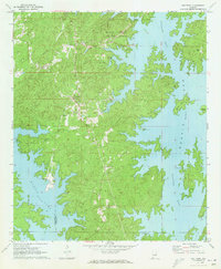
 1971 Mitchell Dam1973 Print · USGSThe Coosa River valley is captured here in the early seventies, dominated by the waters of Mitchell and Jordan Lakes. Researchers can trace rural life through landmarks like Corinth Ch, Williams Cem, and the massive hydroelectric works at Mitchell Dam.2 unique versions available
 - 1971 Map of Tallassee, 1973 Print
 1971 Tallassee1973 Print · USGSThe Tallapoosa River corridor in the early 1970s reveals a landscape shaped by hydroelectric power and traditional rural settlements. Genealogists and local historians can trace family roots through landmarks like Rosehill Cem, Providence Ch, and the mills along Wallahatchee Creek.2 unique versions available
 - 1971 Map of Equality, 1973 Print
 1971 Equality1973 Print · USGSThe Coosa County hill country meets the rising waters of the Tallapoosa during the early 1970s. Genealogists can trace family landmarks like Nixburg Cem and Shiloh Cem or locate the site of the historic Covered Br on Oakachoy Creek.2 unique versions available
 - 1971 Map of Shorter, 1973 Print
 1971 Shorter1973 Print · USGSThe Tallapoosa River country comes alive in the early seventies, showing a landscape of small towns and gravel works. Trace local history at Tysonville, the Cubahatchee Lookout Tower, and Wolfe High Sch.2 unique versions available
 - 1971 Map of La Place, 1973 Print
 1971 La Place1973 Print · USGSMacon County in the early seventies shows a landscape where military history and rural tradition meet along the Tallapoosa River. Researchers can locate the Tuskegee Air Force Base and numerous family churches like Bradford Chapel and Elam Ch.2 unique versions available
 - 1971 Map of Our Town, 1973 Print
 1971 Our Town1973 Print · USGSTallapoosa County and the winding shores of Martin Lake are captured here in the early seventies as recreation and local life converged. Genealogists can trace family names at Mt Zion Cem and Mask Cem or locate the rural settlement of Our Town.2 unique versions available
 - 1971 Map of Rockford SW, 1973 Print
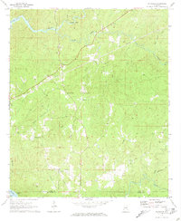
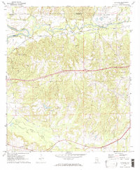
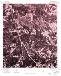
 1971 Rockford SW1973 Print · USGSCoosa County in the early 1970s remains a landscape of upland farms and traditional community anchors. Researchers can trace the heritage of central Alabama through sites like Pentonville, Mt Nebo Ch, and the Lindsey Cem.2 unique versions available
 - 1971 Map of Red Hill, 1973 Print
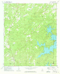
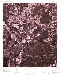
 1971 Red Hill1973 Print · USGSElmore County's winding shoreline and river valley appear here in the early seventies, centered on the infrastructure of Martin Dam. Researchers can trace old rural communities and landmarks like Watson Chapel, Red Hill, and the lakeside Church in the Pines.2 unique versions available
 - 1975 Map of Elmore SE, 1977 Print
 1975 Elmore SE1977 Print · USGSThe river-rich landscape near Elmore is captured here in the mid-1970s through high-altitude aerial photography. Trace the winding paths of the Alabama River and Coosa River or examine the rural layout of the settlement at Elmore.
 - 1975 Map of Mount Meigs NW, 1977 Print
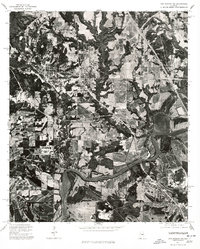
 1975 Mount Meigs NW1977 Print · USGSEast of the state capital in the mid-1970s, this aerial study captures the winding bends of the Tallapoosa River. Local historians can trace the footprint of early development in Montgomery and the rural layout of Madison.
 - 1975 Map of Elmore NE, 1977 Print
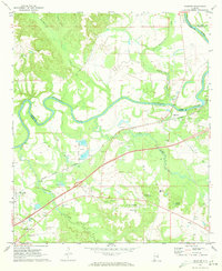
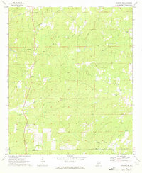
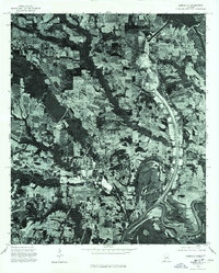
 1975 Elmore NE1977 Print · USGSElmore County during the mid-seventies is revealed through this aerial survey, capturing the rural landscape north of Montgomery. Researchers can trace the wooded shoreline of Jordan Lake and locate the early layout of communities like Holtville and Titus.
 - 1975 Map of Montgomery NW, 1977 Print
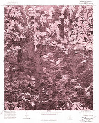
 1975 Montgomery NW1977 Print · USGSThe Alabama River corridor north of Montgomery shows a landscape of deep meanders and developing neighborhoods in the mid-seventies. Local historians can trace the intersection of rural land and new infrastructure along the banks of the Alabama River.
 - 1975 Map of Wetumpka SE, 1977 Print
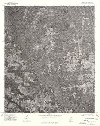
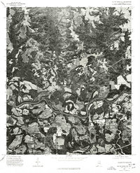
 1975 Wetumpka SE1977 Print · USGSElmore County during the mid-1970s is shown in high-contrast aerial detail, revealing the precise layout of rural homesteads and timberlands. Local researchers can trace the roads and property lines surrounding the settlements of Claud and Good Hope.
 - 1975 Map of Montgomery North, 1977 Print
 1975 Montgomery North1977 Print · USGSThe northern reaches of Montgomery and the winding Alabama River are shown in detail during the mid-1970s. Trace the development of local settlements like Boylston and Brook alongside the dramatic river meanders and growing road networks.
 - 1975 Map of Wetumpka SW, 1977 Print
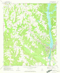
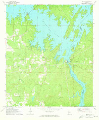
 1975 Wetumpka SW1977 Print · USGSThe riverfront at Wetumpka is captured in detail during the mid-seventies in this aerial survey. Researchers can trace the exact footprint of the town and the natural banks of the Coosa River before decades of modern expansion.
 - 1975 Map of Elmore SW, 1977 Print
 1975 Elmore SW1977 Print · USGSCovers Elmore County, including Prattville, Millbrook, and other nearby areas
 - 1975 Map of Mount Meigs NE, 1977 Print
 1975 Mount Meigs NE1977 Print · USGSCovers Elmore County, including Montgomery, Pike Road, and other nearby areas
End of results
Showing maps 1-18 of 18
Top cities of Elmore County
- Millbrook historical maps
- Wetumpka historical maps
- Holtville historical maps
- Emerald Mountain historical maps
- Deatsville historical maps
- Blue Ridge historical maps
See more
Frequently asked questions
- What are the different types of historical maps available for Elmore County?
- What is the oldest map of Elmore County?
- Where can I purchase historical maps of Elmore County for my home or office?
- Where can I download high-res historical maps of Elmore County?
- Are there historical topographic maps available for Elmore County?
- Is there historical aerial imagery available for Elmore County?
- Where are historical maps of Elmore County sourced from?