1900s (20th Century) Maps of Vina, Alabama
Explore 10 historic maps of Vina from the 1900s (20th Century). These maps offer a rare glimpse into what life looked like during the 1900s — showing old roads, neighborhoods, homes, and landmarks that have changed or disappeared over time.
Whether you're researching your family's past, planning a metal detecting trip, or studying how Vina's landscape evolved across the 1900s, these high-resolution maps are a powerful tool for exploring the history of this region.
- Focus on a specific era: All maps on this page are from the 1900s, giving you a focused view of this time period.
- See what’s changed: Compare century-old streets, trails, and buildings to today's modern landscape using overlays and satellite layers.
- Research with precision: Use these maps for genealogy, historical research, land use analysis, or educational projects.
- View, download, or print: Maps are fully viewable online in high resolution, and can be downloaded or printed for your own records.
Start exploring Vina's history through authentic maps from the 1900s. This is your window into the past.
Vina, AL maps
(10)- 1936 Map of Vina
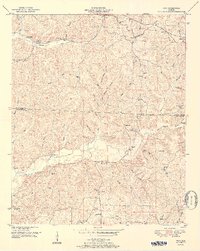
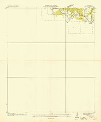 1936 Vina1936 Print · USGSThe area surrounding Vina in the mid-1930s is captured here during a period of infrastructure growth and rural transition. Researchers can locate family landmarks like Jones Cem and trace the path of the Illinois Central railroad.
 - 1936 Map of Halltown
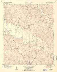
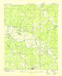 1936 Halltown1936 Print · USGSFranklin County in the mid-1930s is a landscape of creek-side settlements and rural crossroads connected by the Illinois Central railroad. Family historians can locate rural landmarks like Halltown Cem, Coker Sch, and the community of Burntout.
 - 1950 Map of Vina, 1977 Print
 1950 Vina1977 Print · USGSThe Alabama-Mississippi borderlands come to life in this mid-century survey of the upland country near Vina. Genealogists and historians can trace isolated landmarks like Good Spring Church, the Newburg Cem, and the path of the Illinois Central railroad.
 - 1950 Map of Halltown, 1977 Print
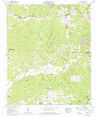
 1950 Halltown1977 Print · USGSFranklin County's rural landscape is captured here at mid-century, showing the quiet growth of Red Bay and Vina. Genealogists can locate family landmarks like Weatherbee Cem, Liberty Hill Church, and the historic site of Old Burleson.
 - 1951 Map of Vina
 1951 Vina1951 Print · USGSNorthwest Alabama at mid-century centers on the corridor between Vina and Shottsville as the rural landscape evolves. Researchers can trace family-named landmarks like Buzzard Bluff, several country schools, and old burial sites such as Brazel Cem and Nichols Cem.2 unique versions available
 - 1951 Map of Halltown
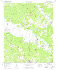
 1951 Halltown1951 Print · USGSFranklin County, Alabama, was a landscape of rail-connected towns and ridge-top churches during the early fifties. Genealogists can trace family roots through Weatherbee Cem, Halltown Cem, and rural landmarks like the Vina Lookout Tower.2 unique versions available
 - 1956 Map of Tupelo, 1967 Print
 1956 Tupelo1967 Print · USGSNortheast Mississippi and parts of Tennessee and Alabama are shown here during the mid-fifties, a time of major reservoir construction and forestry management. Researchers can trace the St Louis-San Francisco RR through Tupelo or locate historic sites like Tishomingo State Park and the University.2 unique versions available
 - 1958 Map of Tupelo
 1958 Tupelo1958 Print · USGSNortheast Mississippi and neighboring Alabama and Tennessee appear here during the late fifties as a region defined by new reservoirs and historic rail lines. Genealogists can trace family locations near Sardis Lake, Woodall Mountain, and the St Louis-San Francisco Ry.
 - 1984 Map of Tupelo
 1984 Tupelo1984 Print · USGSNorth Mississippi in the 1980s is defined by its massive river basin reservoirs and the growing regional hubs of Tupelo and Oxford. Researchers can trace the legacy of the Pontotoc Ridge, find the University of Mississippi, and map early Interstate corridors near Sardis Lake.3 unique versions available
 - 1984 Map of Tupelo, 1985 Print
 1984 Tupelo1985 Print · USGSNortheast Mississippi and the Alabama borderlands are shown in the mid-1980s as timber and river networks shaped the region. Trace local history through the Illinois Central Gulf rail line and sites like the Old Natchez Trace Parkway.
End of results
Showing maps 1-10 of 10
Top cities near Vina
- Hamilton historical maps
- Red Bay historical maps
- Belmont historical maps
- Hackleburg historical maps
- Tremont historical maps
- Hodges historical maps
See more
Frequently asked questions
- What are the different types of historical maps available for Vina?
- What is the oldest map of Vina?
- Where can I purchase historical maps of Vina for my home or office?
- Where can I download high-res historical maps of Vina?
- Are there historical topographic maps available for Vina?
- Is there historical aerial imagery available for Vina?
- Where are historical maps of Vina sourced from?