1900s (20th Century) Maps of Samson, Alabama
Explore 5 historic maps of Samson from the 1900s (20th Century). These maps offer a rare glimpse into what life looked like during the 1900s — showing old roads, neighborhoods, homes, and landmarks that have changed or disappeared over time.
Whether you're researching your family's past, planning a metal detecting trip, or studying how Samson's landscape evolved across the 1900s, these high-resolution maps are a powerful tool for exploring the history of this region.
- Focus on a specific era: All maps on this page are from the 1900s, giving you a focused view of this time period.
- See what’s changed: Compare century-old streets, trails, and buildings to today's modern landscape using overlays and satellite layers.
- Research with precision: Use these maps for genealogy, historical research, land use analysis, or educational projects.
- View, download, or print: Maps are fully viewable online in high resolution, and can be downloaded or printed for your own records.
Start exploring Samson's history through authentic maps from the 1900s. This is your window into the past.
Samson, AL maps
(5)- 1953 Map of Andalusia, 1965 Print
 1953 Andalusia1965 Print · USGSSouth Alabama in the mid-twentieth century remains a land of pine forests and river-fed settlements. You can trace the vital rail corridors of the Louisville & Nashville and locate regional centers such as Andalusia, Brewton, and Monroeville.3 unique versions available
 - 1957 Map of Andalusia
 1957 Andalusia1957 Print · USGSSouthern Alabama in the mid-1950s was a landscape defined by timbered stretches and the rhythmic flow of the Alabama River. Researchers can trace the legacy of the rail era through the Central of Georgia tracks and the storied river bluffs at Choctaw Bluff.
 - 1968 Map of Samson, 1970 Print
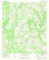
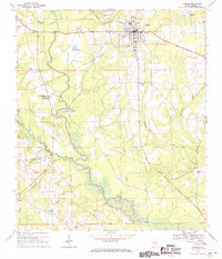 1968 Samson1970 Print · USGSGeneva County life in the late sixties centers on the railroad hub of Samson and the fertile bottomlands of the PEA RIVER. Local researchers can locate family landmarks like Hall and Rivers Cem, the Drive-in Theater, and Oak Ridge Ch.2 unique versions available
 - 1968 Map of Sellersville, 1971 Print
 1968 Sellersville1971 Print · USGSSoutheast Alabama’s agricultural heartland is documented here in the late sixties, showcasing the rural landscape at the border of Coffee and Geneva counties. Genealogists can trace family roots through landmarks like Weeks Cem, Friendship Ch, and the small settlement of Sellersville.2 unique versions available
 - 1986 Map of Andalusia
 1986 Andalusia1986 Print · USGSCovington County and the Wiregrass region are shown here in the mid-1980s, centered on the growing hubs of Andalusia and Opp. Genealogists and local historians can trace legacy sites like the Old Pioneer Cem, Straughn Sch, and the rail lines of the Louisville and Nashville RR.2 unique versions available
End of results
Showing maps 1-5 of 5
Top cities near Samson
- Enterprise historical maps
- Opp historical maps
- Geneva historical maps
- Kinston historical maps
- Eunola historical maps
- Coffee Springs historical maps
Frequently asked questions
- What are the different types of historical maps available for Samson?
- What is the oldest map of Samson?
- Where can I purchase historical maps of Samson for my home or office?
- Where can I download high-res historical maps of Samson?
- Are there historical topographic maps available for Samson?
- Is there historical aerial imagery available for Samson?
- Where are historical maps of Samson sourced from?