1970s Maps of Tarrant, Alabama
Explore 3 historic maps of Tarrant from the 1970s. These maps offer a rare glimpse into what life looked like during the 1970s — showing old roads, neighborhoods, homes, and landmarks that have changed or disappeared over time.
Whether you're researching your family's past, planning a metal detecting trip, or studying how Tarrant's landscape evolved across the 1970s, these high-resolution maps are a powerful tool for exploring the history of this region.
- Focus on a specific era: All maps on this page are from the 1970s, giving you a focused view of this time period.
- See what’s changed: Compare century-old streets, trails, and buildings to today's modern landscape using overlays and satellite layers.
- Research with precision: Use these maps for genealogy, historical research, land use analysis, or educational projects.
- View, download, or print: Maps are fully viewable online in high resolution, and can be downloaded or printed for your own records.
Start exploring Tarrant's history through authentic maps from the 1970s. This is your window into the past.
Tarrant, AL maps
(3)- 1975 Map of Irondale, 1977 Print
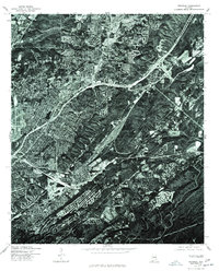 1975 Irondale1977 Print · USGSThe industrial and residential growth of Jefferson County is visible in this mid-seventies aerial survey, showing the landscape just as the modern interstate system matured. Trace the development of Irondale and its surrounding ridge-and-valley terrain.
 - 1975 Map of Birmingham North, 1977 Print
 1975 Birmingham North1977 Print · USGSNorthern Alabama's urban and industrial core is captured in sharp detail during the mid-seventies. Trace the literal footprint of the city and its surrounding developments from Birmingham to the clearing and quarries of Fultondale.
 - 1975 Map of Gardendale, 1977 Print
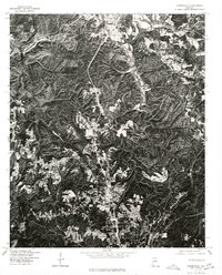 1975 Gardendale1977 Print · USGSJefferson County residential growth and Appalachian ridge terrain are clearly visible in the mid-1970s. Researchers can trace the development of Gardendale, the layout of Mt Olive, and the rural character surrounding Morris.
End of results
Showing maps 1-3 of 3
Top cities near Tarrant
- Birmingham historical maps
- Hoover historical maps
- Hoover historical maps
- Vestavia Hills historical maps
- Homewood historical maps
- Trussville historical maps
See more
Top neighborhoods of Tarrant
- Tarrant Garden Estates historical maps
- Bartonville historical maps
- Black Creek historical maps
- Danville historical maps
- Humoro historical maps
- Ketona historical maps
See more
Frequently asked questions
- What are the different types of historical maps available for Tarrant?
- What is the oldest map of Tarrant?
- Where can I purchase historical maps of Tarrant for my home or office?
- Where can I download high-res historical maps of Tarrant?
- Are there historical topographic maps available for Tarrant?
- Is there historical aerial imagery available for Tarrant?
- Where are historical maps of Tarrant sourced from?