1930s Maps of Moulton, Alabama
Explore 6 historic maps of Moulton from the 1930s. These maps offer a rare glimpse into what life looked like during the 1930s — showing old roads, neighborhoods, homes, and landmarks that have changed or disappeared over time.
Whether you're researching your family's past, planning a metal detecting trip, or studying how Moulton's landscape evolved across the 1930s, these high-resolution maps are a powerful tool for exploring the history of this region.
- Focus on a specific era: All maps on this page are from the 1930s, giving you a focused view of this time period.
- See what’s changed: Compare century-old streets, trails, and buildings to today's modern landscape using overlays and satellite layers.
- Research with precision: Use these maps for genealogy, historical research, land use analysis, or educational projects.
- View, download, or print: Maps are fully viewable online in high resolution, and can be downloaded or printed for your own records.
Start exploring Moulton's history through authentic maps from the 1930s. This is your window into the past.
Moulton, AL maps
(6)- 1935 Map of Moulton
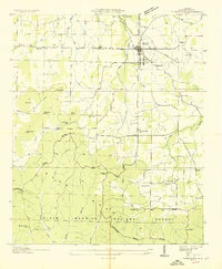 1935 Moulton1935 Print · USGSLawrence County during the mid-thirties reveals a rural landscape poised between the plateau farms and the timbered heights of the national forest. Researchers can trace family history through local sites like the Rosenwald Sch, Shoemaker Cem, and the settlement at Wren.
 - 1935 Map of Danville
 1935 Danville1935 Print · USGSIn the mid-thirties, the borderlands of Lawrence and Morgan counties featured a landscape of remote stores and hilltop churches. Genealogists can trace family footprints at Strauge Crossroads or locate the ancient Indian Mounds near Oakville.2 unique versions available
 - 1935 Map of Oakville
 1935 Oakville1935 Print · USGSLawrence County, Alabama, is documented here in the mid-1930s as a landscape of small schools, family cemeteries, and ancient landmarks. Genealogists and historians can trace the locations of the Indian Mounds, Hodges Store, and several rural anchors like Oakville Sch.
 - 1936 Map of Moulton
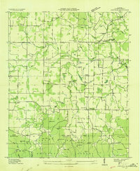
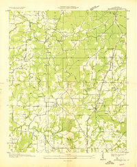
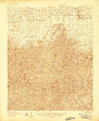 1936 Moulton1936 Print · USGSLawrence County in the mid-1930s shows a landscape of rural schools and family cemeteries clustered around Moulton. Genealogists and historians can trace the foundations of Rabbitt Town and Landersville or locate Shoemaker Cem and CCC Camp 12.2 unique versions available
 - 1936 Map of Masterson
 1936 Masterson1936 Print · USGSLawrence County, Alabama, is captured here in the mid-1930s as the Tennessee Valley Authority began transforming the region's infrastructure. Researchers can locate early rural landmarks like Masterson Mill, Grahams Race Track, and Old Bethel Ch.
 - 1938 Map of Danville
 1938 Danville1938 Print · USGSNorthern Alabama’s uplands are captured here in the mid-1930s, showing the early boundaries of the Black Warrior National Forest. Researchers can locate rural schools and churches like Speake Sch and Evergreen Ch or trace old crossings at McDaniel Bridge.2 unique versions available
End of results
Showing maps 1-6 of 6
Top cities near Moulton
- Decatur historical maps
- Athens historical maps
- Trinity historical maps
- Town Creek historical maps
- Courtland historical maps
- North Courtland historical maps
See more
Frequently asked questions
- What are the different types of historical maps available for Moulton?
- What is the oldest map of Moulton?
- Where can I purchase historical maps of Moulton for my home or office?
- Where can I download high-res historical maps of Moulton?
- Are there historical topographic maps available for Moulton?
- Is there historical aerial imagery available for Moulton?
- Where are historical maps of Moulton sourced from?