1940s Maps of Asbury, Alabama
Explore 2 historic maps of Asbury from the 1940s. These maps offer a rare glimpse into what life looked like during the 1940s — showing old roads, neighborhoods, homes, and landmarks that have changed or disappeared over time.
Whether you're researching your family's past, planning a metal detecting trip, or studying how Asbury's landscape evolved across the 1940s, these high-resolution maps are a powerful tool for exploring the history of this region.
- Focus on a specific era: All maps on this page are from the 1940s, giving you a focused view of this time period.
- See what’s changed: Compare century-old streets, trails, and buildings to today's modern landscape using overlays and satellite layers.
- Research with precision: Use these maps for genealogy, historical research, land use analysis, or educational projects.
- View, download, or print: Maps are fully viewable online in high resolution, and can be downloaded or printed for your own records.
Start exploring Asbury's history through authentic maps from the 1940s. This is your window into the past.
Asbury, AL maps
(2)- 1947 Map of Columbus City, 1972 Print
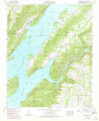 1947 Columbus City1972 Print · USGSThe Alabama shoreline and Marshall County highlands are captured here after the Tennessee River was dammed to form Guntersville Lake. Genealogists can trace old family sites like Rainey Cem and settlements at Columbus City or Meltonsville.3 unique versions available
 - 1949 Map of Columbus City
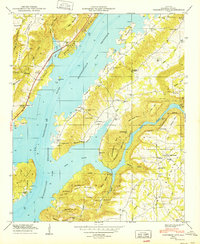 1949 Columbus City1949 Print · USGSInundated valleys and high ridges define this Marshall County landscape just after the war as the Tennessee River reshapes the local geography. Researchers can find old family cemeteries like Kennamer Cem and communities such as Columbus City.2 unique versions available
End of results
Showing maps 1-2 of 2
Top cities near Asbury
- Albertville historical maps
- Scottsboro historical maps
- Boaz historical maps
- Guntersville historical maps
- Whitesboro historical maps
- Crossville historical maps
See more
Frequently asked questions
- What are the different types of historical maps available for Asbury?
- What is the oldest map of Asbury?
- Where can I purchase historical maps of Asbury for my home or office?
- Where can I download high-res historical maps of Asbury?
- Are there historical topographic maps available for Asbury?
- Is there historical aerial imagery available for Asbury?
- Where are historical maps of Asbury sourced from?