1940s Maps of Cottage Park Estates, Alabama
Explore 2 historic maps of Cottage Park Estates from the 1940s. These maps offer a rare glimpse into what life looked like during the 1940s — showing old roads, neighborhoods, homes, and landmarks that have changed or disappeared over time.
Whether you're researching your family's past, planning a metal detecting trip, or studying how Cottage Park Estates's landscape evolved across the 1940s, these high-resolution maps are a powerful tool for exploring the history of this region.
- Focus on a specific era: All maps on this page are from the 1940s, giving you a focused view of this time period.
- See what’s changed: Compare century-old streets, trails, and buildings to today's modern landscape using overlays and satellite layers.
- Research with precision: Use these maps for genealogy, historical research, land use analysis, or educational projects.
- View, download, or print: Maps are fully viewable online in high resolution, and can be downloaded or printed for your own records.
Start exploring Cottage Park Estates's history through authentic maps from the 1940s. This is your window into the past.
Cottage Park Estates, AL maps
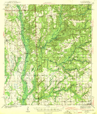
(2)- 1941 Map of Hurley, 1953 Print
 1941 Hurley1953 Print · USGSThe borderlands between Mississippi and Alabama are captured here in the early 1940s as rural life centered on the river and rail. Local researchers can trace family landmarks and forgotten road networks from Hurley to St Elmo, including Tanners Cem, Baker Sch, and Slaughter Flat Landing.3 unique versions available
 - 1943 Map of Hurley
 1943 Hurley1943 Print · USGSCoastal Mississippi and Alabama are surveyed here during the early war years, showing the rural communities between the rivers and the growing Gulf coast. Genealogists can locate family landmarks like Tanners Cem, Roberts Chapel, and the settlement of Nut Bank along the river bluffs.2 unique versions available
End of results
Showing maps 1-2 of 2
Top cities near Cottage Park Estates
- Mobile historical maps
- Prichard historical maps
- Tillmans Corner historical maps
- Saraland historical maps
- Moss Point historical maps
- Satsuma historical maps
See more
Frequently asked questions
- What are the different types of historical maps available for Cottage Park Estates?
- What is the oldest map of Cottage Park Estates?
- Where can I purchase historical maps of Cottage Park Estates for my home or office?
- Where can I download high-res historical maps of Cottage Park Estates?
- Are there historical topographic maps available for Cottage Park Estates?
- Is there historical aerial imagery available for Cottage Park Estates?
- Where are historical maps of Cottage Park Estates sourced from?