1940s Maps of Eva, Alabama
Explore 2 historic maps of Eva from the 1940s. These maps offer a rare glimpse into what life looked like during the 1940s — showing old roads, neighborhoods, homes, and landmarks that have changed or disappeared over time.
Whether you're researching your family's past, planning a metal detecting trip, or studying how Eva's landscape evolved across the 1940s, these high-resolution maps are a powerful tool for exploring the history of this region.
- Focus on a specific era: All maps on this page are from the 1940s, giving you a focused view of this time period.
- See what’s changed: Compare century-old streets, trails, and buildings to today's modern landscape using overlays and satellite layers.
- Research with precision: Use these maps for genealogy, historical research, land use analysis, or educational projects.
- View, download, or print: Maps are fully viewable online in high resolution, and can be downloaded or printed for your own records.
Start exploring Eva's history through authentic maps from the 1940s. This is your window into the past.
Eva, AL maps
(2)- 1949 Map of Lawrence Cove, 1977 Print
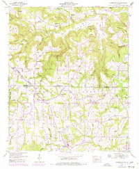 1949 Lawrence Cove1977 Print · USGSBrindley Mountain and the Tennessee Valley Divide define the rural landscape of Morgan and Cullman counties just after the war. Local researchers can trace family landmarks like the Lawrence Cove School, Canaan Cem, and the high concentration of country churches including Etha Ch and Bethel Ch.
 - 1949 Map of Eva, 1977 Print
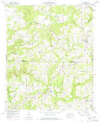 1949 Eva1977 Print · USGSThe Morgan and Cullman County line in the mid-twentieth century was a region of ridge-top farms and deep hollows. Genealogists and local historians can trace the foundations of these communities through landmarks like Gravel Hill Church, the Louisville and Nashville rail corridor at Vinemont, and Turney Cem.
End of results
Showing maps 1-2 of 2
Top cities near Eva
- Huntsville historical maps
- Decatur historical maps
- Cullman historical maps
- Hartselle historical maps
- Arab historical maps
- Priceville historical maps
See more
Frequently asked questions
- What are the different types of historical maps available for Eva?
- What is the oldest map of Eva?
- Where can I purchase historical maps of Eva for my home or office?
- Where can I download high-res historical maps of Eva?
- Are there historical topographic maps available for Eva?
- Is there historical aerial imagery available for Eva?
- Where are historical maps of Eva sourced from?