1930s Maps of Eva, Alabama
Explore 2 historic maps of Eva from the 1930s. These maps offer a rare glimpse into what life looked like during the 1930s — showing old roads, neighborhoods, homes, and landmarks that have changed or disappeared over time.
Whether you're researching your family's past, planning a metal detecting trip, or studying how Eva's landscape evolved across the 1930s, these high-resolution maps are a powerful tool for exploring the history of this region.
- Focus on a specific era: All maps on this page are from the 1930s, giving you a focused view of this time period.
- See what’s changed: Compare century-old streets, trails, and buildings to today's modern landscape using overlays and satellite layers.
- Research with precision: Use these maps for genealogy, historical research, land use analysis, or educational projects.
- View, download, or print: Maps are fully viewable online in high resolution, and can be downloaded or printed for your own records.
Start exploring Eva's history through authentic maps from the 1930s. This is your window into the past.
Eva, AL maps
(2)- 1936 Map of Eva
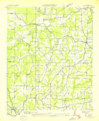 1936 Eva1936 Print · USGSThe Morgan and Cullman county line was a landscape of ridge-top settlements and creek valleys in the mid-1930s. Genealogists can trace family footprints at Dripping Spring Sch, Hamby Chapel, and the Morris Cem near the railroad.
 - 1936 Map of Lawrence Cove
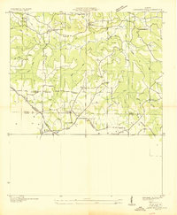 1936 Lawrence Cove1936 Print · USGSMorgan County rural life is captured here in the mid-1930s, showing a landscape of small farming communities and ridge-top churches. Trace the local genealogy of Lawrence Cove through landmarks like Lawrence Cove Sch, Pine Burr Ch, and Bethel Ch.
End of results
Showing maps 1-2 of 2
Top cities near Eva
- Huntsville historical maps
- Decatur historical maps
- Cullman historical maps
- Hartselle historical maps
- Arab historical maps
- Priceville historical maps
See more
Frequently asked questions
- What are the different types of historical maps available for Eva?
- What is the oldest map of Eva?
- Where can I purchase historical maps of Eva for my home or office?
- Where can I download high-res historical maps of Eva?
- Are there historical topographic maps available for Eva?
- Is there historical aerial imagery available for Eva?
- Where are historical maps of Eva sourced from?